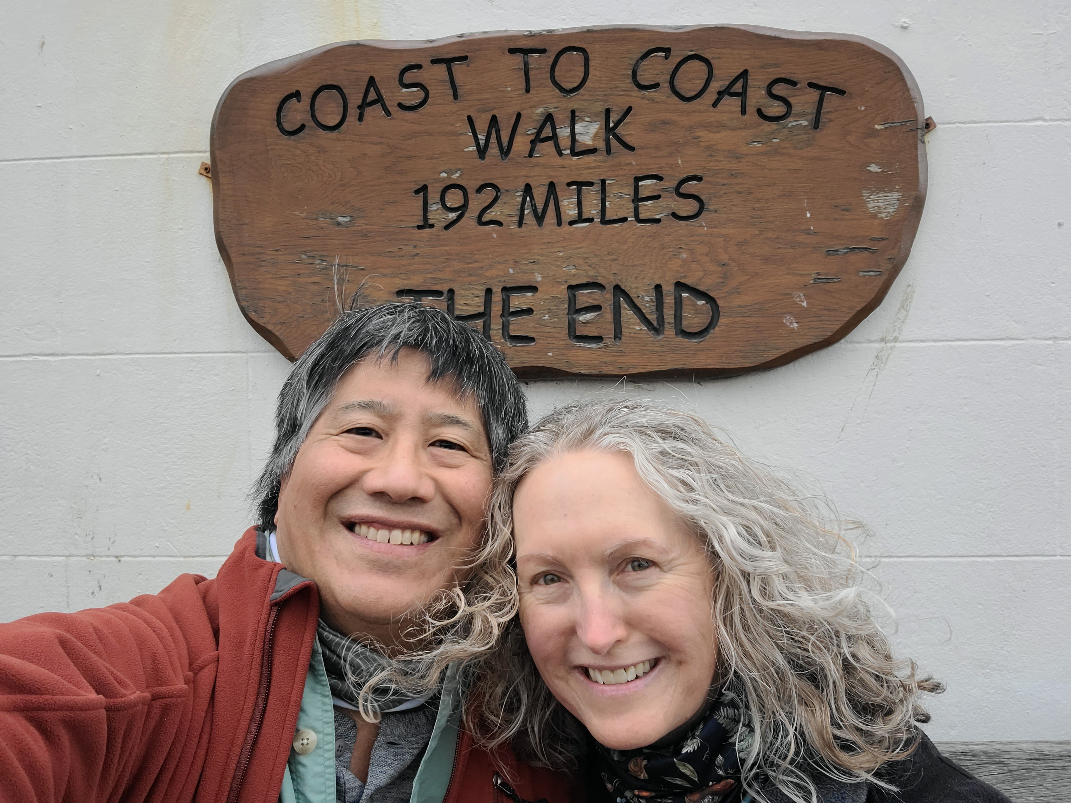
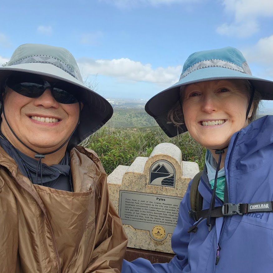
We did it!
Uploading photos and hand-coding HTML are tedious tasks, so this page is, for now, an ongoing project. Im starting it in May 2026, almost exactly two years later. My goal is at least to pull all the relevant content from our Instagram pages and put it in one place, where we can re-live our trip without having to scroll through multiple years of Insta fodder.
We highly recommend Mickeldore Travel for arranging hotels and working with Packhorse, the luggage forwarding company.
The Coast to Coast route runs through three very different national parks: the Lake District (think "Snow White and the Huntsman"), the Yorkshire Dales (think "All Creatures Great and Small" or "The Last of the Summer Wine"), and the North York Moors (think "Vera"). Our very first hiking day was a day of absolutely torrential rains, following (as the locals delighted in telling us) one of the wettest Winter and Spring seasons in memory. The rain was so blindingly heavy, we made the decision to divert from the route, opting to follow a bike path and then B-roads to our destination. Ondine had to trust Johns old Boy Scout map and compass skills (our Harvey topo map was water-resistant, but didnt include several detours, including this one) coupled with Avenza Maps, the mapping and GIS app he uses for work. (John is an archaeologist, a formerly experienced Sierras backpacker, and taught Orienteering in the Boy Scouts.)
The next couple days were also quite wet, off and on, so we never got to really appreciate the spectacular views possible from the tops of the fells, and scrambling up and down the trail of rainslicked, muddy slate rocks bordered at times on the semi-technical (were looking at you, Greenup Edge). We later learned that the area, which had by early May already received half its usual rainfall for the month, received fully the other half in a single day while we were hiking! But, the weather improved, and although it technically could be said that it rained almost every day, it generally didnt rain enough to stop us. Mostly, we had beautiful, perfect cloudy-damp hiking days, and one really hot day. And, John really appreciated not having to wear glasses in the drizzle; his cataract surgery the previous month helped out a lot, although he now needed glasses to read the map and navigate!
Despite relatively light signposting, especially through the Lake District, navigation on the route was easy as long as you paid attention and knew what you were doing. With all the criss-crossing trails and forks, the Coast to Coast is definitely not something to walk on autopilot!
Ondine got a blister under her toenail the very first day that was a problem until Kirkby Stephen, our second layover day, when she saw a podiatrist. Johns feet and knees were annoyingly fine the entire trip, despite soggy feet for the first week and a total route elevation gain and loss equivalent to doing Everest. John did a couple days hiking solo, on days when Ondines foot or knees needed a rest. Hes now a total convert to Injinji toe socks, by the way; he used the Injinji liners under Darn Tough Coolmax mid-weight boot socks, and is now using Injiniji Coolmax mid-weight hiking socks as his everyday work socks.
Some of our favorite memories are the places we had layover days: Crookabeck near Patterdale, Bollam Cottage on the outskirts of Kirkby Stephen (home of "the Cathedral of the Dales"), 66 Frenchgate in Richmond (where we saw a musical: USS Pinafore, Gilbert and Sullivans HMS Pinafore set on a starship), Great Broughton (where we went into nearby Stokesley and had an epically good meal at a tiny Italian restaurant called Uno Momento, then missed our stop taking the bus back, ending up at a friendly bar a few towns over), and the Fernleigh in Robin Hoods Bay (where we met up with Desiree and her friend Carola, went to a local "curry and a pint night," and John found a belemnite fossil on the beach). We also took the historic Ullswater Ferry. And John got to see archaeology every day, ranging from the Victorian industrial landscape all the way back to Bronze Age barrows and stone circles. Roman and Medieval stuff was simply everywhere. Another favorite hotel was the Westmorland in the unlikely spot of Tebay, basically a motorway stop with an excellent farm-to-table hotel and restaurant with an attached farm shop, run by the local farmers whose land was used to make the motorway.
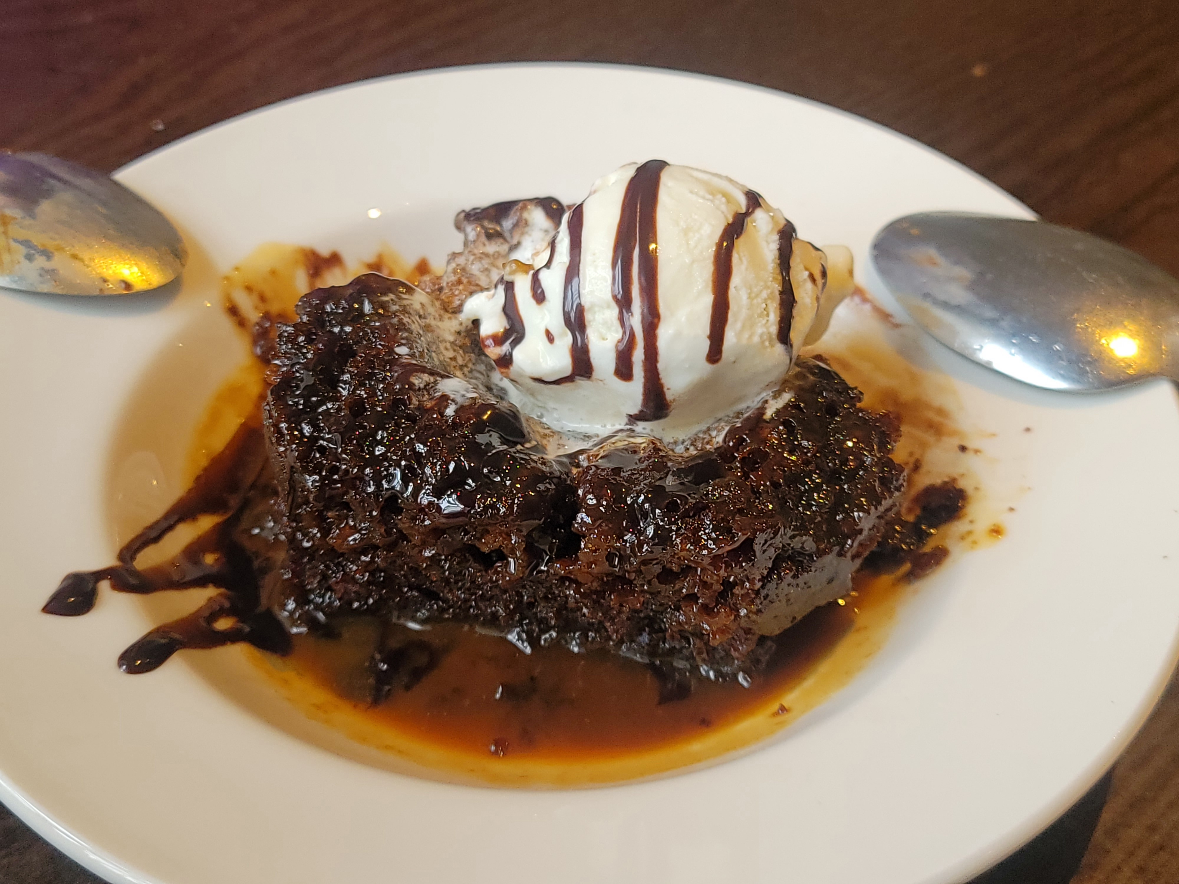
The food was uniformly good to excellent, with a few amazing meals thrown in for good measure, like the home-made pancetta risotto and berry brulee at Park House in Arncliffe Woods. The only disappointment was the world-famous Shap Chippy, which wed eagerly anticipated for years leading up to the trip; the reality was not even up to being mediocre. Even the pre-packed sandwiches from the Co-ops were fresh and very tasty, and the packed lunches made by the hotels were all hearty and often a highlight of the days hike. John scored all of his food grails: smoky bacon crisps (very hard to find but amazing, in the same family as bbq potato chips but better), a Curly Wurly bar (like a Marathon bar, remember those?), a Tizer (the fruity-herby soft drink we need in this country), Polo candies (like peppermint Lifesavers, but harder and more peppery and less chalky and altogether better), a pork pie (way more porky and uniformly textured than expected but very tasty), a Bitter Lemon (a tart, sparkly mixer that seems to be out of fashion; only one place had it the whole trip), a stop at a Costa Coffee (think British Starbucks), sticky toffee pudding (very sticky, quite rich, and sweet), and roly poly pudding and jam (sickeningly sweet, as expected from one reference in a P.G. Wodehouse story). He even enjoyed a bit of black pudding!
Our gear mostly worked out great, and we didnt significantly overpack. John carried a Gregory Zulu 30, and Ondine an Osprey Sirrus 24; both had more than enough room to carry everything wed need for a day without crushing our packed lunches too badly. For everything else, we also each took a Travelpro soft-sided carry-on sized rolling suitcase, which was forwarded by van to the next destination, along with Johns CPAP. The SnugPak rain ponchos wed bought with this trip in mind turned out to be the ideal solution, and although we also packed rain jackets (John: Patagonia Torrentshell 3L; Ondine Marmot Precip Eco) we only used them in town. Ondine found that shed packed a bit too tightly for daily unpacking and packing, so we ended up going to an Oxfam charity shop in Richmond and scoring a gray Slazenger duffel bag for £4, which is now one of our favorite souvenirs.
Johns favorite souvenir is the belemnite fossil he found, but we also spent our last large British notes on a couple books at Heathrow on our way home. Ondine got Underland by Robert MacFarlane, and John got Stoner by John Williams.
The only significant equipment failure was Ondines Black Diamond trekking poles, although John was less than thrilled with his Gregory Zulu 30 backpack for reasons likely unique to him.
Photos and videos are on our respective Instagram pages, although in Johns case hes such an active poster that you have to scroll back a lot to get to them. Johns IG is @archaeoka (its private, so send him a follow request and if he knows you, youre in) and Ondines is @ondine.alegra, if you want to know what were up to now. Also, theres our weekly family journal of everyday life.
On the way down, the sun came out and we were startled by a big coiled rattlesnake next to the trail! Fortunately, it rattled a warning so we could give it the space it needed to slide away into the underbrush. Whew!
My snake gaiters are in my car, ready to go for work. Crews have already seen three or four rattlesnakes around the job sites.
The Coast to Coast may have lots of rain, but no rattlesnakes!
May 10


Its really happening! Were off on our Wainwright Coast to Coast adventure starting tomorrow! This 192-mile walking
vacation has been about seven years in the making, saving up and making plans.
But first, we had to make a quick trip to REI because Ondine realized her $30 sign-up gift card would expire during our trip, and THAT couldnt be allowed to happen. Then, we had a bite to eat at Niban, very nearby. Wed never tried Niban, so it felt like a little pre-adventure adventure. The food was excellent, Id highly recommend the "Bento A," which I had!
May 11
And were off! Ondine and I are about to fly direct to London Heathrow, then catch a commuter flight to
Manchester for our first night on British soil!
The weather forecast for our first week on the trail: so much rain!
May 13

Landing in MAN after a grueling 11-hour, middle-seat flight from SAN to LHR sat next to a woman who (a) initially took up my entire footwell with her carry-on bag and (b) said it was big because it was full of meds because she was VERY SICK. Then, she proved to be a talkative, touchy person. While coughing. Yeeks!
The man behind Ondine, meanwhile, was coughing up a lung and sounding miserable the whole way, poor guy.
The baby in front of us and the small child behind, meanwhile, were perfectly well behaved (although the sick woman next to me complained to the parents of the child that he was "screaming in my ear").
On the plus side, we got dinner (vegetarian Thai red curry) and breakfast (pre-packed "full English"). And, I finally saw "The Holdovers" with Paul Giamatti, it was pretty good!
May 13
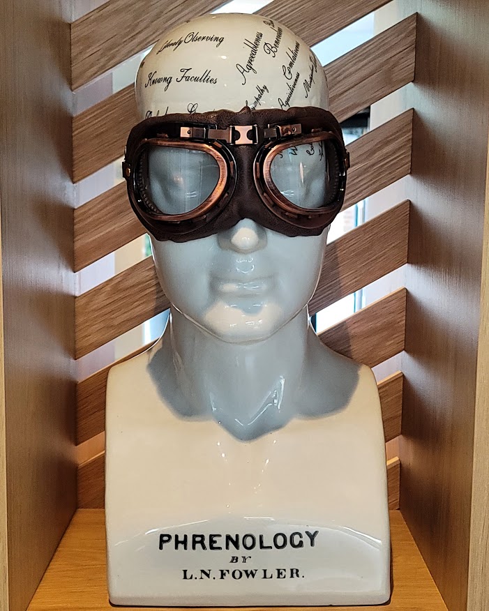
The Holiday Inn Manchester Airport lobby decor straight spoofin on the pseudoscience.
May 13
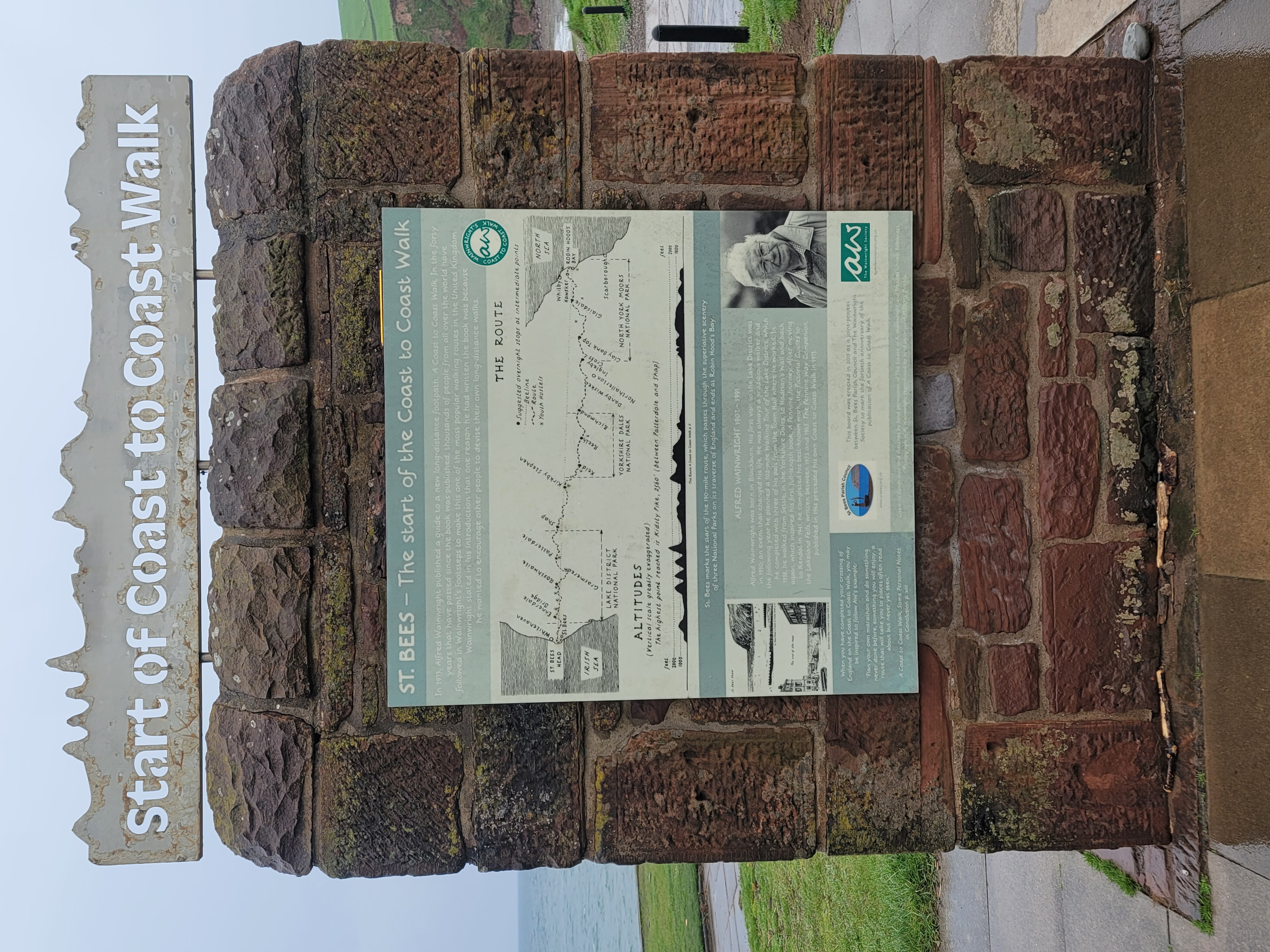
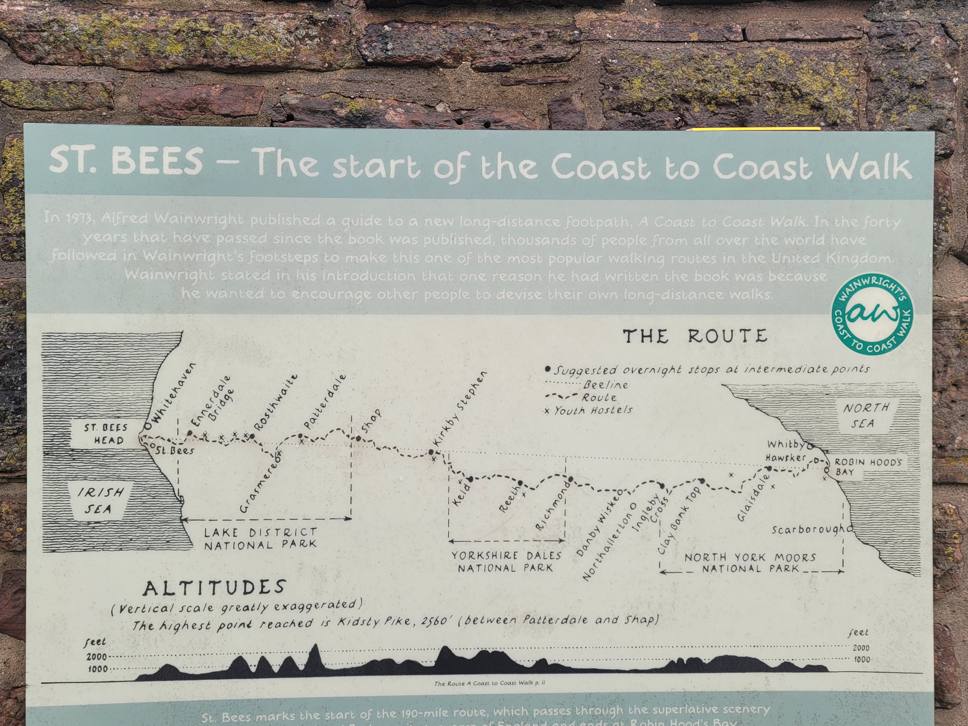
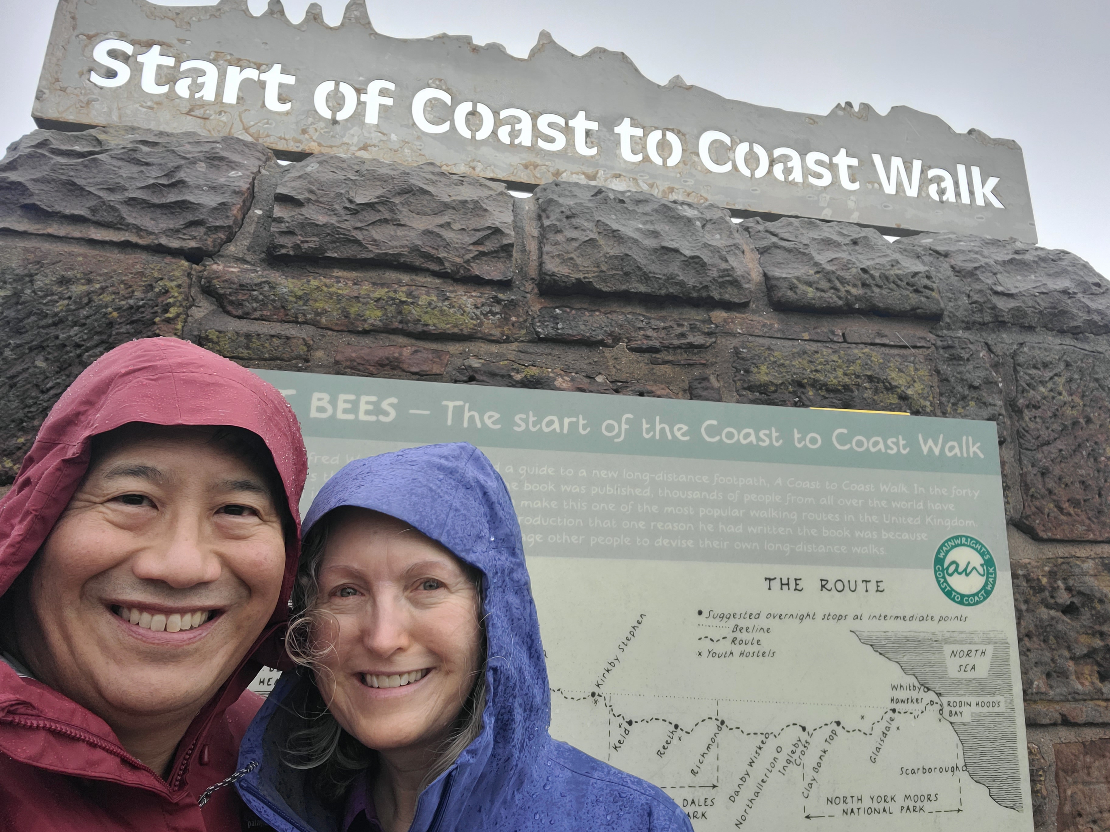
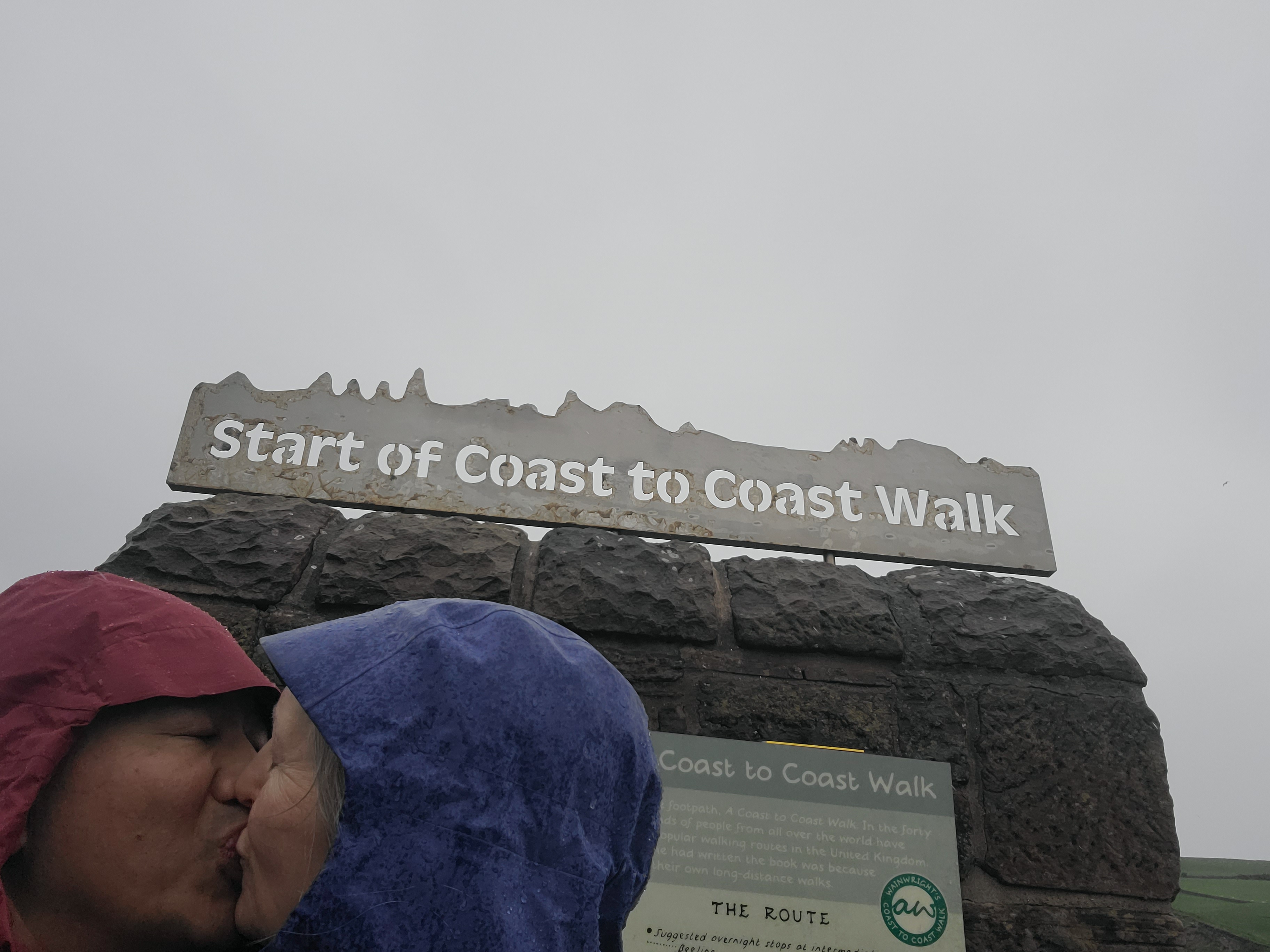
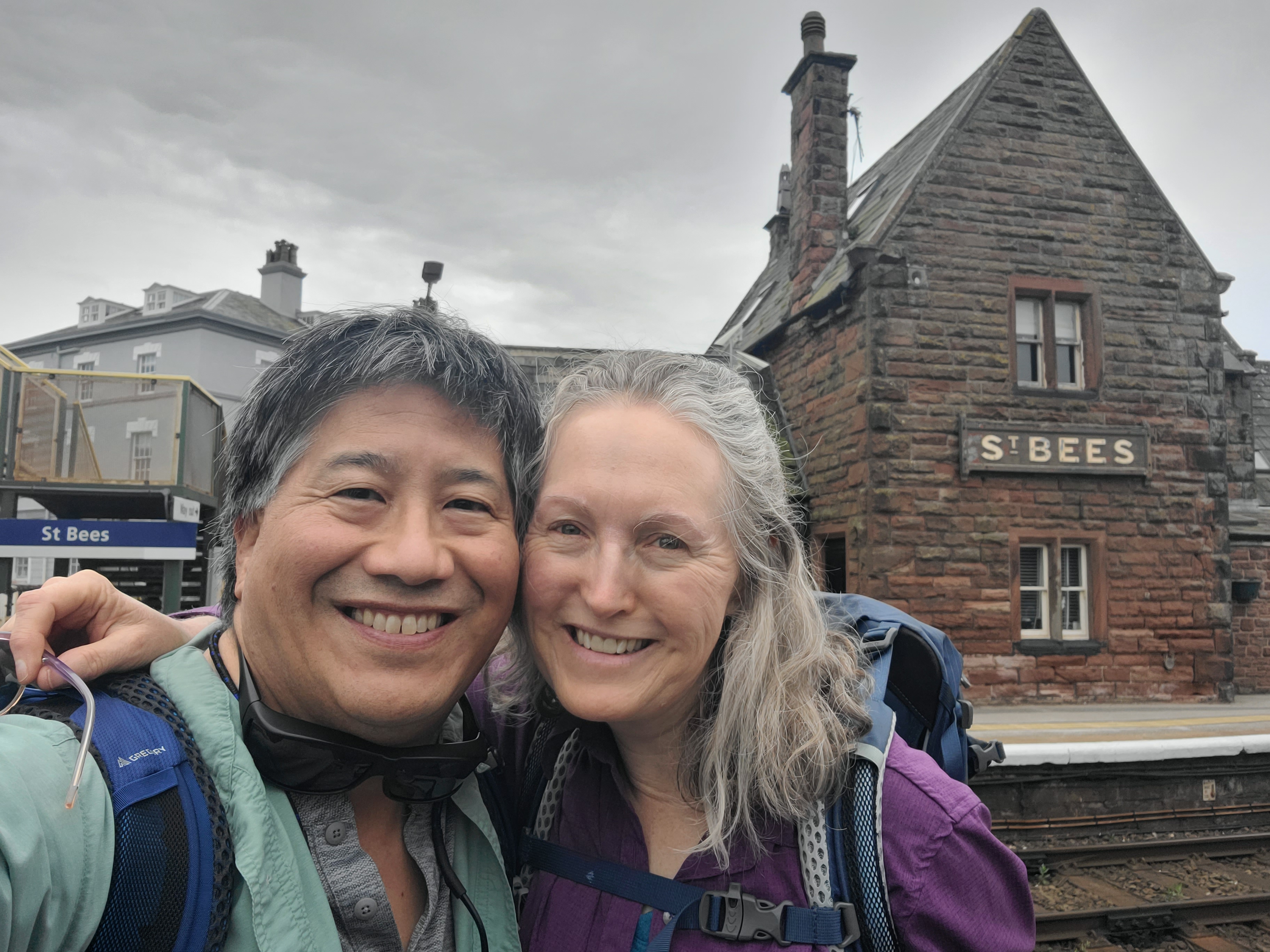
We arrived at St. Bees, the official starting point for the 192-mile Wainwright Coast to Coast walk! We actually start the walk tomorrow morning.
This afternoon, it started raining, and the forecast calls for 100% chance of rain all day tomorrow for our first leg of the journey, a 16-17 mile walk. More than one local has told us (either gleefully or sympathetically) that this season has been the wettest in memory.
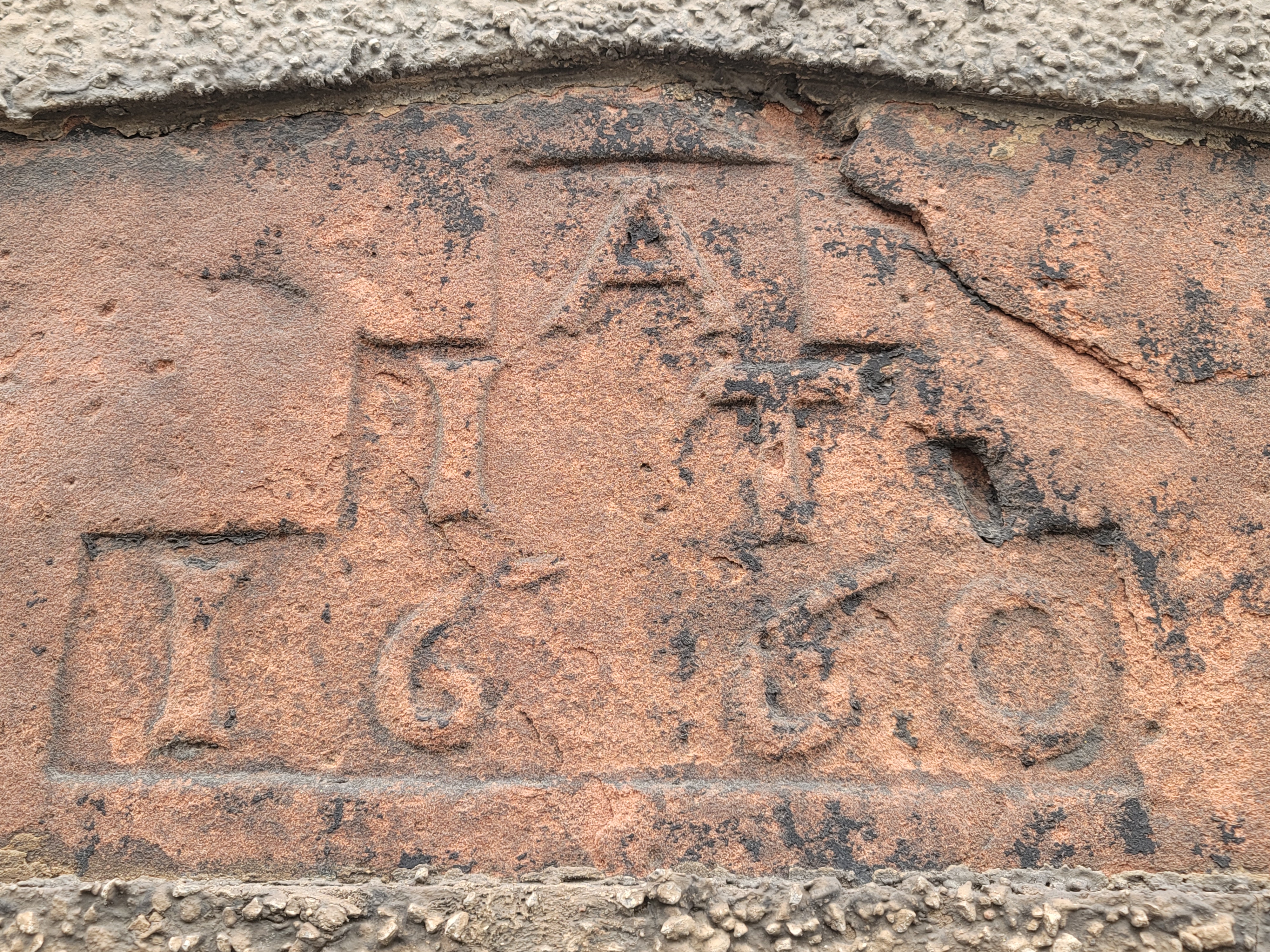
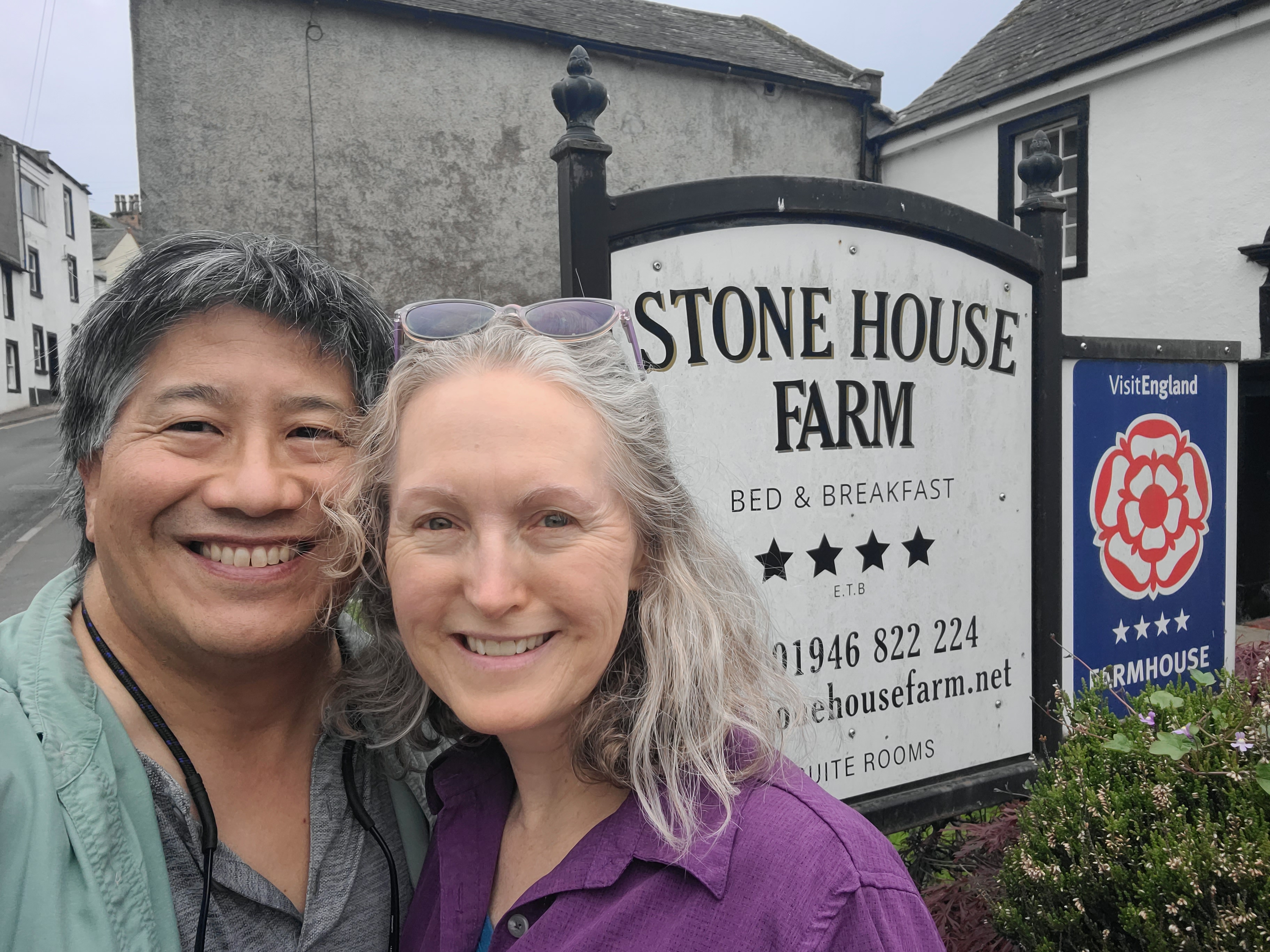
Heres Stone House Farm, the B&B where were staying the night. The cottage were in (the grayish building directly behind us) was built in 1660, as shown in the original brickwork beneath the modern stone cladding!
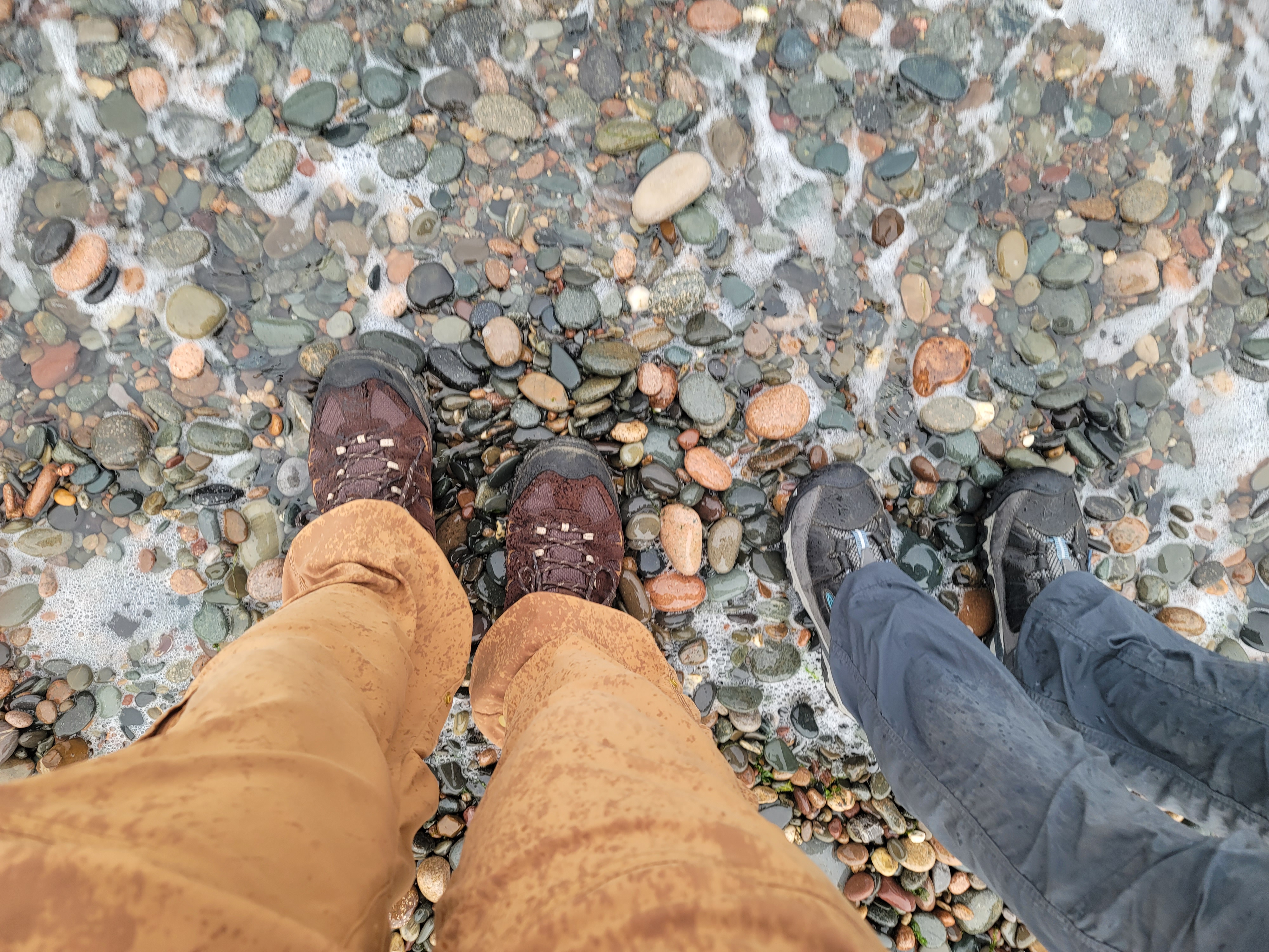
The last photo shows us dipping our boots in the Irish Sea, a C2C tradition, along with picking out a pebble to toss into the North Sea at the end.
Here are a couple videos:
The Coast to Coast sign, and the offical starting point of the Wainwright Coast to Coast Walk
The start of our walk, tomorrow!
May 13
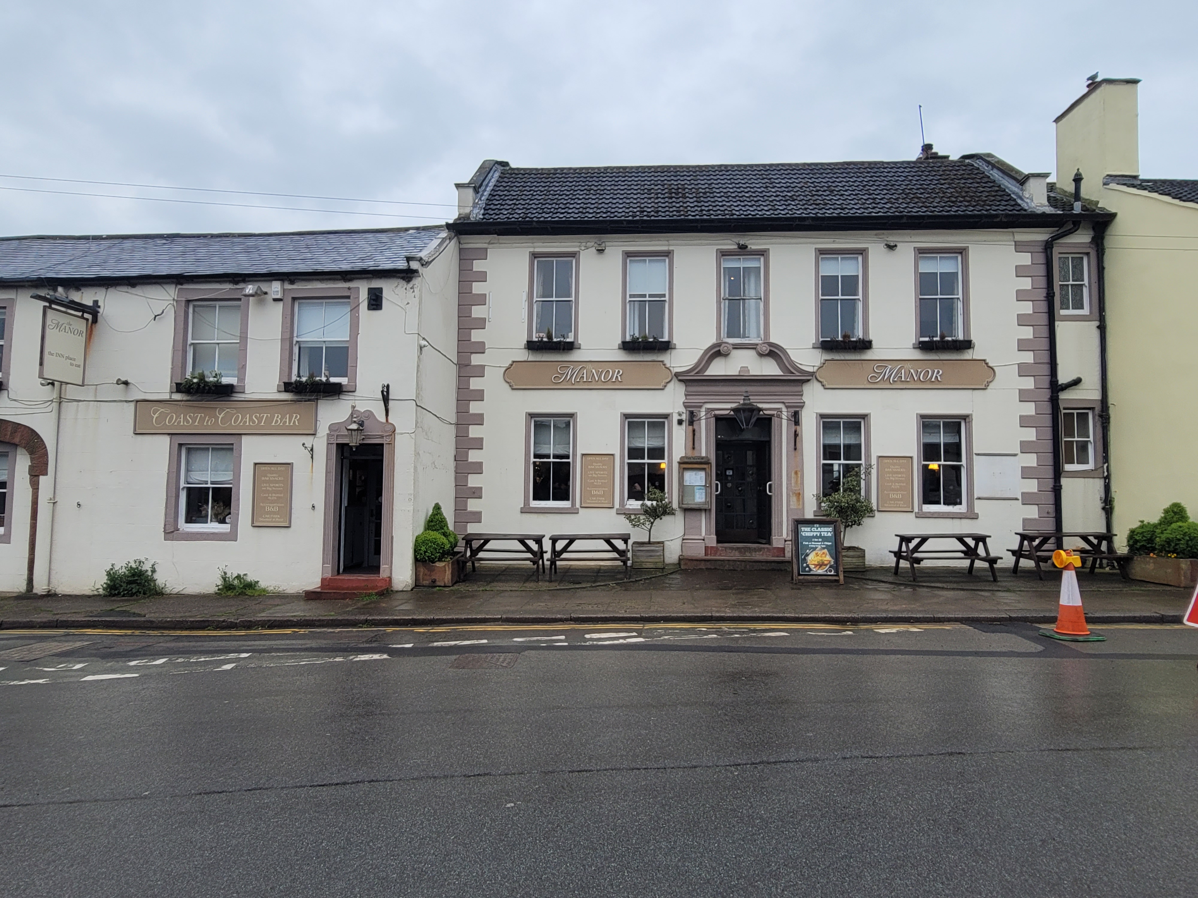
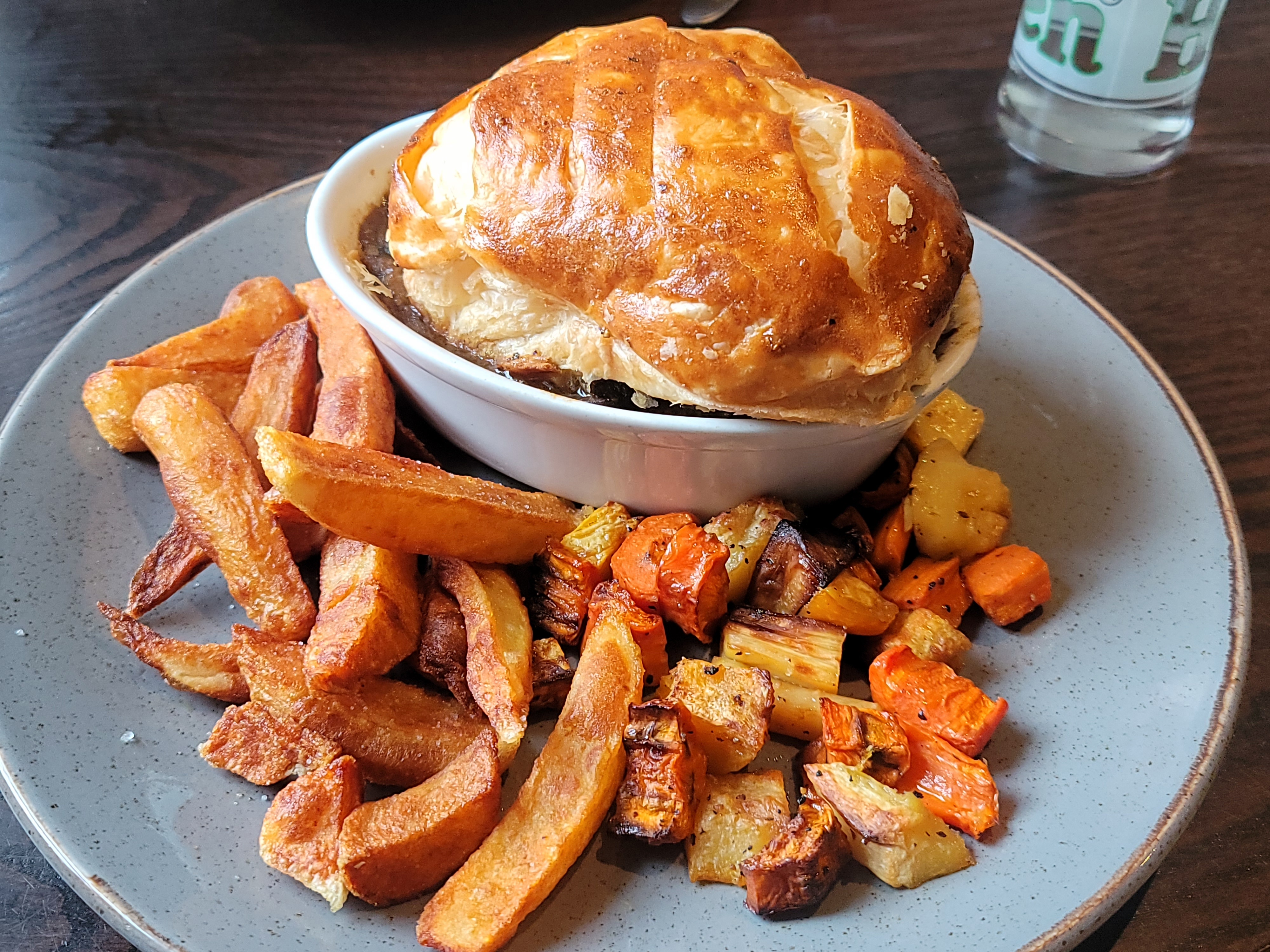
Join us for dinner at The Manor Inn, the only place in St Bees serving dinner on a Monday. I had steak and ale pie with roasted root veg and chips, Ondine had beef brisket with roasted root veg and mash, and we shared a sticky toffee pudding. Everything was freshly cooked in-house from locally sourced ingredients, and it was all absolutely delicious, the best meal weve had on this trip by far!
The Manor Inn used to be St Bees actual manor house. Our walk earlier today took us by the old priory, which was a originally a Norman-built Benedictine monastery dating from 1120 until Henry VIIIs dissolution/seizing of church property in 1539. Even the neighborhood school dates from 1583!
May 14
St Bees to Ennerdale Bridge with Ondine, 14 miles as planned, 15 miles as executed. We had rain all day, occasionally quite hard. At Moor Row it was bucketing down rain and hail so hard we ducked into a bus shelter to lay out Plan B: forgoing Dent Hill and its increasingly doubtful prospect of views (and for certain one of the steepest descents of the CtoC) in lieu of a lush, green path along a cycle path, then taking a road that wound past working farms into town.
The guidebook was little help and the Harvey map even less because we were now off the main route and making our own way. But, between Avenzas OSM beta and encounters with helpful locals who let us know we were on the right track (in particular a runner who was out with a dog and four playful puppies) we managed to hold our course.
Still, when we turned a corner and our hotel was suddenly in front of us, we couldnt help but feel absolutely elated. We made it!
May 14
video
And then the rain got heavier. Then the HAIL started pelting us, making us dive into a nearby bus shelter to plot our next move, which was to skirt Dent Hill via a C2C cycleway.
Later, snug and warm, we spoke briefly with a pair of uberfit Norwegian women who followed the guidebook up and down Dent Hill. They said it was "horrible," no view, slippery, and difficult route-finding in the weather. And they hit it long before we would have, when the rain was still relatively light.
So, we made the right call here!
May 14
Photo of me this morning by Ondine. The poncho over my backpack makes me look like a monk, stooped with age, picking my way along the clifftop with my basket of gorseberries ??
May 14
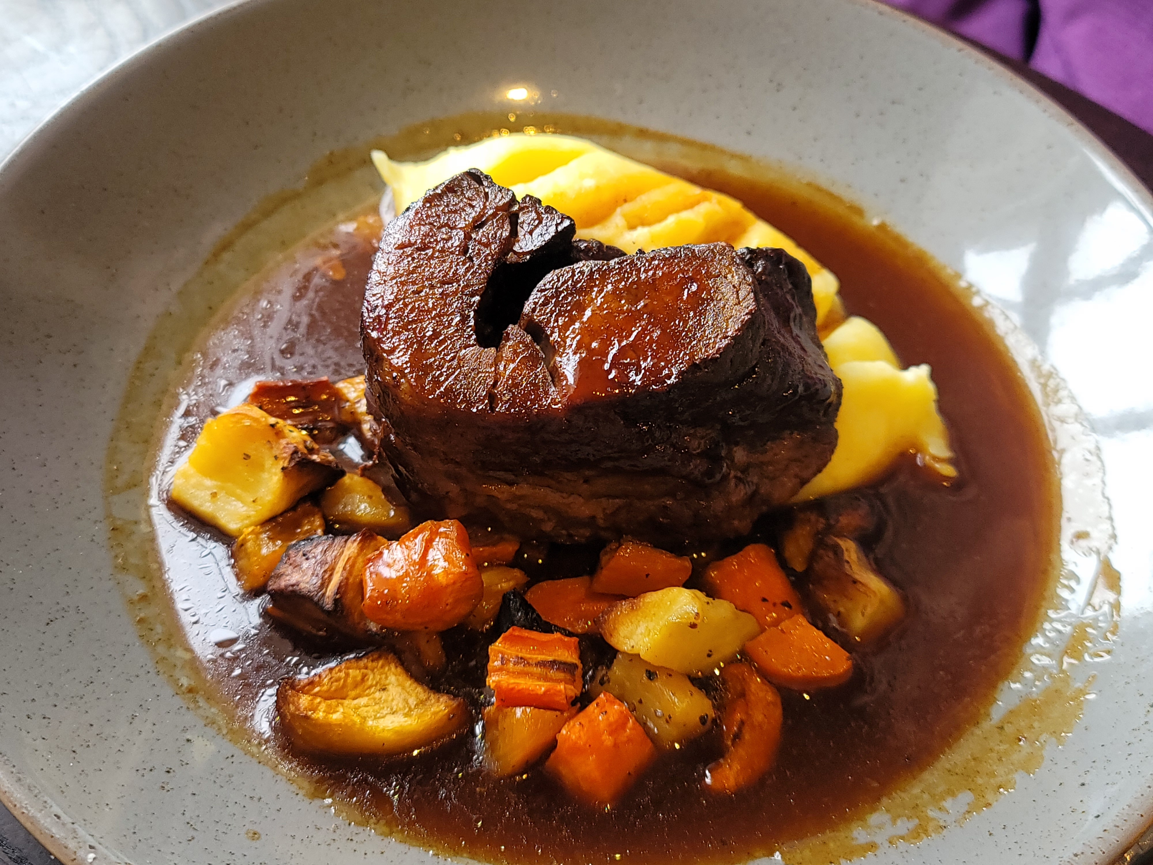
My dinner at The Shepherds Arms: steak and ale pie with chips and some cooked veg (carrots, broc, red cabbage) out of shot. A very satisfying meal after a tough first day on the trail! Ondine had pork medallions in a fresh tarragon sauce, also quite good and just what was needed. She was hungry, so no pic of her food!
Btw, its not that Im a mega fan of steak and ale pie - although it is something we dont see often in the states - its that menu options at these small inns are hand-crafted and very limited (Ondine got the last serving of garlic rosemary potatoes, for instance, and we overheard some people being disappointed). So, of the handful of choices, this just hit right two days in a row. If you compare it to yesterdays, youll see each steak and ale pie is its own creation.
May 15
Todays hike: Ennerdale Bridge to Stonethwaite, map says 15.5 miles, Samsung says 36,852 steps.
1 - Me and Ondine at Ennerdale Water, a reservoir. We chose an absolutely dreamy lakeside amble through the woods to the far end, where the forest-strolly north and rock-scrambly south trails converge.
2 - Black Sail Youth Hostel, which has an honesty kitchen where we enjoyed a nice cuppa tea before starting the steady, rock-stepped crank up Loft Beck.
3 - Us on the trail. Thats the River Liza coming down the valley behind us. See the creek that joins it to the left? Thats Loft Beck. The trail goes straight up beside it, and the picture just doesnt reveal what a vertical cascade it is! Were wearing ponchos because it was, yup, raining.
4 - John on the way to Loft Beck.
5 - Ondine steadily climbing up Loft Beck. At least the rain let up a bit.
6 - Us at the Honister Slate Mine, about to head down the fell to dinner and into bed!
May 15
Bonus shots from today, the first two from near the start of the hike and the last two from near the end. Note the industrial landscape of the last two photos.
Photo 3 shows the top of the path down to the Honister Slate Mine, which follows an old tram track. The pile of rubble at this end is the remains of the old drum house, which housed the big cable drum that drove the tram.
Photo 4 shows traces of historic mining activity, including tailings, what looks like some sort of elevated work line, tunnels, and foundations.
May 15
Dinner at the Langstrath Country Inn, our home for the night. We both started with a wonderful homemade tomato soup. Then, Ondine had coconut chickpea curry with chicken and fragrant rice, and I had this succulent pan-fried salmon with asparagus, broccoli, bok choi, and new potatoes. We also shared a side salad. Good food and a great end to the day!
Also fun: catching up with trail friends!
May 15
Because I know yall can read a topo map, heres the section from Black Sail Hut up Loft Beck from yesterday. We followed the red dashed low route, but a few hardy trail friends went the pink high route over the Haystacks and by Innominate Tarn, where Alfred Wainwrights ashes were scattered. Contour interval: 15m. Map from Harvey Maps via Avenza.
May 16
Ennerdale Bridge to Grasmere, an easy 9-mile stroll. Piece of cake, right? Nope!
Ondine made the mistake of saying, aloud, "well, at least nothing today is going to be worse than Loft Beck," to which the Lakeland gods said, "hold my beer."
The climb up Greenup Gill to Lining Crag and then up again to Greenup Edge in drizzle to light rain was like Loft Beck, only without the nice stone steps. Avenza kept us on track, but the route was a wet, muddy, steep scramble straight up the rocks of a running creek. Im a former (mediocre) climber and caver. I wouldnt call this climb semi-technical, but it was semi-semi-technical, in large part due to loose and slippery footing in the wet, and no real handholds. Again, the photos just dont show the verticality of the thing.
It was a relief to clamber over the ridge and down a boggy valley that was partially paved with stones. The path improved and the grade decreased as we plodded down and down the long, long valley to lovely Grasmere, land of Wordsworth, a full 7 hours after leaving Ennerdale Bridge.
May 16
Join us for dinner at The Inn at Grasmere: roasted pepper, beetroot, and chickpea salad with mixed leaves and a lemon vinaigrette (fresh and very tasty), and pizza with mushrooms, peppers, and olives (also quite good).
We sat in the bar, sharing a table with a Canadian couple who are also walking the Coast to Coast, but with full backpacks. It was great to commiserate with them not only about the climb over Greenup today, but also the utter inscrutability of guidebooks.
May 16
Must .. resist ... poking ... around ... in ... the ... lovely ... ruins ...
An out-of-use structure under the watchful eye of Eagle Crag.
May 17
Photos of yours truly from yesterday, from Ondine.
1 - Looking at Eagle Crag and Sergeants Crag.
2 - Starting the ascent to the base of Lining Crag and Greenup Edge.
3 - Historic gateposts still being used as the pathway! The fence used to extend all the way down the valley. Archaeologically, some of the oldest things around are field boundaries, many well-established and documented in the Domesday Book (1086). So, although these specific metal gateposts may be historic, the placement of a gate at this location may be much, much older.
4 - Walking into Grasmere.
May 17
Grasmere to Patterdale, 8.5 miles by guidebook, Samsung says 10.5. We did some shopping in Grasmere, though, and our B&B is a ways out of town.
1 - William Wordsworths grave at St Oswalds in Grasmere.
2 - Me and Ondine starting out.
3 - Cranking up and over Gavel Crag to Grisedale Tarn.
4 & 5 - Grisedale Tarn. Two people were swimming!
6 - We came from somewhere up there!
7 - Ruthwaite Beck, near Ruthwaite Lodge.
8 Sheeps.
May 17
Our "Grazing Boards" at the Crookabeck B&B, one charcuterie and one vegetarian to share. Nomnomnom!
Crookabeck B&B is a bit out of the way, but its worth it!
May 17
Ok @edenriverstrust, heres what the two photo stations at Grisedale Beck looked like today, 17 May 2024, at 16:44. (We love otters, and hope the habitat restoration attracts some!)
Everyone else: for more information about why Im posting these shots, see the third photo.
May 18
Architectural history is everywhere! Photo 1 - See the ghost opening in the dry stone wall? Photo 2 - Check out the slate drip line overhang built into the gable wall (photo 3 has my markup pointing it out). The gable of this structure has no significant roof overhang, so I suspect this line of slate is there to prevent water from eroding the ground at the gable foundation. This would use a lot less slate and other materials than making the whole roof stick out further. Socioeconomic history is *also* everywhere!
May 18
What a layover day looks like in Crookabeck, near Patterdale.
1 - Crookabeck B&B, our fabulous home for two luscious nights! 11/10, we highly recommend.
2 - Cat!
3 - When did I start looking this ... Dad? I look like Im checking car insurance quotes. Im probably trying to book two tickets on an historic steam ferry. Or looking at maps of tomorrows journey. Or editing photos. Or posting, again.
4 - Hoisting a quick half of Black Sheep Best Bitter at The White Lion, our temporary local.
5 - Roasted beetroot, feta, walnut, and spring green salad, also at The White Lion.
6 - Steak and mushroom pie with veg and chips at The White Lion.
7 - Always room for local Lake District ice cream!
May 19
Flippin eck! Todays weather in northwest England: beautiful > sunny > warm, bright, and pleasant > hot and humid > massive thunderstorm > sheets of rain > hot and humid > warm, gray, and breezy > cool and breezy > cold and windy.
VIDEO
May 19
Archaeology on the go! From a ride across Ullswater on a historic steam ferry, to prehistoric mounds and stone circles on Askham Fell, to Victorian quarries, to historic stone farm buildings, to 12th century abbey ruins, its all here today.
1 - Cop Stone, an unworked stone upright on Askham Fell thats part of a scheduled (recorded and protected), 20-meter wide stone circle, some of which can still be seen as exposed upright rocks and arc-shaped mounds. The archaeology beneath this structure is left undisturbed, but geophys and even excavations have been done on similar structures, and have revealed burials, charcoal, and middens thought to be related to Bronze Age funerary practices. Exciting stuff!
2 and 3 - More ghost doorways!
4 - Sheep vert! Yes, I always have a photo scale, usually better than this, but I was in a hurry.
5 - Me in front of the ruins of Shap Abbey, just outside Shap.
May 19
Everyone takes the same photos of Shap Abbey. Here are some of mine, from yesterday. I may update later with more history, but I think one of the more interesting things about it is that when Henry VIIIs men took over after the dissolution of the monasteries, the Shap churchmen (like most who surrendered voluntarily) were given a royal pension. Thats not just Henry VIII being kind, or helping to allay bad feelings (or the *look* of bad feelings); its a major "I AM the boss of you" power play.
The other interesting thing, is that the whole abbey grounds are part of a currently working farm dating back to the dissolution itself. So, flashing forward to modern times, English Heritage had to work with them to establish, build, and maintain public access.
Photo 3 is looking up the nave to the entrance. Note the beautifully carved pillar footings.
Photo 5 shows how the nicely cut and dressed outer limestone blocks were scavenged for local buildings, revealing the walls inner rubble core.
Photo 6 shows the scavenged chapel end of the abbey.
May 20
The changing landscape of the Coast to Coast. Were now in the Westmorland Dales, and suddenly there are no crags, the hills are rolling, and even the sheep seem more chill.
1 - The Hardendale or Shapfell Quarry, which processes limestone from the surrounding areas.
2 - Limestone pavement along the trail.
3 - A structure!
4 - We go off trail to make a mile-long detour at the farmers request because hed just brought water for his cows.
5 - It looks like beautiful pillowy hillsides, but theres solid limestone just beneath the surface. Those undulations are just the way the limestone is.
May 20
VIDEO
You get pretty good at climbing over stiles on the Coast to Coast.
May 20
Ahhhh, dinner at the Westmorland Hotel, Tebay. Everything is fresh and VERY locally sourced - as in the hotel and service station were built and run by the local farmers after the M6 was run through their land. Thats our starters, carrot, apple, and fennel soup and a couple of chopped salads.
Then, Johns butternut squash and roasted red pepper risotto and Ondines grilled steak, mushrooms, and veg. Everything was AMAZING, so fresh-tasting and lively!
Oh, and here we are, showered and changed. We packed very light, small suitcases, so we actually have no "trail clothes/hotel clothes," only "clean clothes/dirty clothes." And our definition of "clean clothes" is ... flexible.
May 22
I didnt post yesterday because we connected with another couple for dinner at The Mango Tree in the town of Kirkby Stephen (pronounced "kirbee steven"), then had to walk to the Co-op for various ointments and oddments. Anyway, yesterdays walk from Orton to Kirkby Stephen was a lovely 13-mile hike over the Westmorland and Yorkshire Dales, through the Sunbiggin Tarn bird sanctuary and part of the Yorkshire Dales National Park.
1 - Our breakfast view at the Westmorland Hotel in Tebay. When we first saw it on our itinerary ("Westmorland Hotel and Tebay Motorway Services") we thought, "were staying in a truck stop." But this was one of the best stays weve had, a spacious room, superb service, and amazing farm-to-table food.
2 - Gamelands Stone Circle, dating back to the late Neolithic/early Bronze Age, 3,500 to 6,000 years ago. Not all the stones are here, and not all the stones here are original.
3 - Dry stone fence with two Shap granite boulders: the two with pink inclusions. Theres not a lot of granite in the area, its mostly sandstone, limestone, and slate. One of the few sources of granite is near Shap, and its distinguished by the large pink feldspar crystals.
4 - Ondine on the trail.
5 - Sheep vert, thoracic!
6 - Severals Village, a very important Romano-British archaeological site on the hillside near a stream crossing. There apparently was a sign asking people to stay off the lumps and bumps; that probably attracted more attention and damage than just leaving the site unmarked, as it is now. Most people just pass it by. The photo doesnt show it well, but in real life by eye you can clearly distinguish this area from the surrounding, smoother, hills. The site itself is an irregular settlement revealed by lumps and bumps and changes in vegetation. Aerial photos show it up best. It has not been excavated. Cool!
7 - View to a boarded-up railway cottage.
8 - Thats Smardale Bridge (18th Century "with additions") over Scandal Beck, originally used for packhorses. The Severals Village complex probably included some of the hillside on the lower right. The trail winds around a bit before crossing the bridge.
10, 11, 12 - Sheeps! Cows! And, in the distance, the Nine Standards high on a distant ridge; you can see then in real life with the naked eye. Theyre on that sharp ridge edge about in the center. Photo 12 is a zoomed-in, enhanced photo of the Nine Standards, the purpose of which is still hotly debated. (All together now: "Must be ritual!")
13 - The trail goes through that abandoned railway underpass and emerges on a haul road in the middle of a working farm. We arrived just in time for all the sheep to be going nuts: it was feeding time! The trail diverts around the farm before dropping into Kirkby Stephen.
May 22
That previous post got a bit long, but there was so much archaeology to see! If youre actually interested, its worth reading all the captions, which rabbit on several comments deep.
Here are Ondine and I on the trail yesterday, taking a little lunch break on some stones around the CtoC signpost overlooking Bents Farm Camping. Got a little rain and drizzle, and it stayed cool, gray, and breezy all day - perfect hiking weather!
May 22
We had a layover day today, and it was a good day to den up indoors: the weather forecast called for "torrential" downpours all day.
We did venture out in the rain to get dinner. And, you know its a good pub when dogs are welcome. This is the Black Bull in Kirby Stephen. We saw several dogs stretched out on the floor by their owners at the bar.
We sat at a wooden table, watching the rain steadily pour down, listening to the locals, and sipping tomato basil soup and eating a hearty meal. Thats Johns steak and ale pie with mash and garden peas, and Ondines beef lasagne.
Heres also where we chatted to a couple with packs who had tried to get up the Nine Standards and into Keld today. They said the trail to the Nine Standards was boggy and impassable, so they fell back to the usually safe Green (low-level) route to Keld only to find even that trail bogged out and unfindable in the mire! At that point, they bailed, walking back to Kirby Stephen and booking a taxi to their next booked accommodation.
When their taxi arrived, John went out and chatted with the driver, getting his card just in case. If tomorrow is anything like today, a taxi may be the safest way to go. This is a vacation, after all. And today - today was great!
UPDATE: The weatherman on the evening news said that HALF the usual May rainfall for the area fell TODAY, with more on the way tomorrow.
Also, we heard from the couple who had dinner with us last night; they were headed to Keld today. They took the road route in, 11 miles on a wet B-road with cars, farm vehicles, and lorries.
May 23
Some views around outside Kirkby Stephen Parish Church, also referred to as "The Cathedral of the Dales." There has been a place of worship here since Saxon times, and probably before then. The current building is an amalgamation of several periods of building, dereliction, and rebuilding and extension, going back to 1170 (yes, Norman era), some evidence of which can be seen in a quick walkaround.
I love the finished local sandstone corner blocks with old brick, and the carved corniced drip break on the angled blocks.
In the last photo, note the double 90-degree buttressing on the chancel (right) vs the single 45 degree buttressing on the transept (left).
Cool stuff!
May 23
Inside Kirkby Stephen Parish Church: the vertical shots
1 and 2 - The famous "Loki Stone," a carved depiction of a bound character with horns and a beard. It was part of this site complex, and dates from the 10th Century. The current interpretation is that its part of an Anglo-Danish cross shaft. The character is thought to be the Norse god Loki and an early Christian representation of the devil in human form.
3 - A 17th Century carved font designed by the same guy who did the Chaucer Window in Westminster Abbey.
4 - Stained glass!
5 - The main chancel and altar.
6 - I included this sign because it mentions, halfway down, the Westmorland Archaeological Society, which erected the pulpit. Theology and archaeology and antiquarianism go together, often in an attempt to, among other things, prove the superiority of one group over another. Still, those early archaeologists produced some sterling work, leading no doubt to some uncomfortable Society meetings when the data didnt support the desired interpretation.
7 - Plus, they did put up an impressive pulpit.
8 - More stained glass, this one from the altar.
9 - Archaeology! Stuff found during demolition, excavation, expansion, and construction. I may try to post my favorite details.
May 23
Its all about the food. Thats a burger and a mushroom tarragon pudding from the Black Bull in Kirkby Stephen Then, pumpkinseed bread, fresh veg soup, beef in Black Sheep ale with new potatoes, puff pastry, and veg (basically a deconstructed steak and ale pie), and veg lasagne with greens from the Keld Lodge in Keld, the official halfway point in the Coast to Coast.
You dont go hungry on this trek, thats for sure!
May 23
How today started, and how it ended. We started at Bollam Cottage in Kirkby Stephen, and ended at Keld Lodge in Keld, at the halfway point on our journey! And now were officially in Yorkshire!
The Herriot Way cuts through here too. Thats a 53-mile loop trail, typically done in four 13-mile days, in the heart of Alf Wights actual practice area. It also includes many of the filming locations from the original (1980s) BBC TV series, "All Creatures Great and Small."
May 24
VIDEO
Great Rampsholme Cowhouse, where cows would winter. There would have been a loft in that second room for more hay, which would also provide insulation. The high opening you see is called a forking hole. The passage I walk through is the foddergang" - Scandanavian influence. Note the concrete floors in the cow stalls, which would have originally been paved with stone, and how theres a trough in the middle for easier mucking out. The opening in that part of the barn is partly for ventilation, but its called a muck hole! The manure would fertilize the feed crops in the fields surrounding the cowhouse.
Cool stuff is everywhere!
May 25
Heading out today aaaaalll byyyyyy myyselllllff from Reeth, headed to Richmond.
May 25
After todays hike, we went to see a comic operetta at the Georgian Theatre Royal in Richmond, the most-complete original Georgian theater in the UK and the oldest and most-original one still operating, complete with boxes and bench seating!
The show was "USS Pinafore," HMS Pinafore set on a starship. Gilbert & Sullivan baked a lot of *very* current social commentary into their original libretto, so the story and songs need very little tweaking to suddenly be both funny and painfully relevant.
Great cast, voices, and show, and a hilarious Star Trek/Star Wars/Sci Fi/Fandom mashup - we feel very lucky to have caught the final show!
May 25
Photo dump from Friday, 24 May, Keld to Reeth. 11 miles plus a side trip of about 1.5 miles total. This will be just the scenery; Ill post the archaeology next.
1 - Ondine and I leaving Keld Lodge, the halfway point on the Coast to Coast!
2 - Waterfall on Swinner Gill, which feeds the Swale River. The "high route" goes up to the ridge along Swinner Gill to a series of abandoned mines and smelting mills. But well take the "low route," which follows the Swale along the lovely valley of Swaledale.
3 - Even from below, you can see ample evidence of mining and milling. Look at the huge tailings scree at the upper right.
4 - The flagstone path into Muker (mew-ker"), one of James Herriots favorite places in the Yorkshire Dales. Ondine is probably filming.
5 - The path to Muker goes through a series of hay meadows. All the flowers and grasses are feed crops that, when mown and dried, become the hay that sustains the cows through the harsh winter months.
6 - A lovely bridge into the hamlet of Ivelet.
7 - Bunny skull! Lots of dead bunnies about in various states of decomposition.
May 26
Archaeology/Cultural Anthropology photo dump from Friday, 24 May, Keld to Reeth, Part 1.
1 - Photogenic ruins on the trail, but the broken corner reveals construction details.
2 - Wall/structure construction. Walls consist of two walls, possibly filled with rubble, tied together with transverse locking stones. The material comes from the ground all around - all the fields had to be broken up to make them arable.
3 - An arch. The location makes me think it was a roadway bridge spanning the watercourse, but my cursory research hasnt turned up a definitive answer.
4 - The scar at the bottom left is glacial; the tailings mound around the tree at upper right is man-made.
5 - This appears to be a house, not a barn or outbuilding. If it were in San Diego, itd be listed as a fixer for $1.8 million. Anyway, it seems to be in current as a sheepfold.
6 - Great Rampsholme Cowhouse. I posted a video walk through earlier.
7 - The fodder storage area (or "mew"), looking into the stalls (or "booses). Theres a lot of Scandanavian influence in the local language: for instance, the passage between this area and the booses is the foddergang.
8 - The booses, or stalls, where two cows would be tethered side by side, separated by the smaller post. The other section is a recess for ... something else. This area would be topped by a loft with more feed and supplies, which would provide added insulation.
May 26
Keld to Reeth, 24 May 2024, archaeology photo dump part 2. What do you think? See all the ghost openings? Some of them looked to me like they may have been first doors, then windows, then closed up (Im not sure if any like that show up in the photos).
These are whats left of Lane Foot. An archaeological survey was done in 2003 by Don McLellan, with consolidation (additional research and reporting) by Matt Spensley and Ken Cooper, and financial aid from the UKs Department for Environment, Food, and Rural Affairs (DEFRA). You can read the interpretive sign by Timothy Bagenal in the last photo (the IG cropped version of which cut out the above credits).
But, an abridged version is that this was originally two cottages with sheds, first built in the late 1600s and expanded in the mid 1700s. By 1841, two families, one mining and one farming, with up to 14 people lived here, so this was a bustling place! By 1891 it was uninhabited, but remained with the farming family until 1951.
May 26
Join Ondine and me for dinner at the Brasserie on the Green in the Burgoyne Hotel in Reeth, Friday evening, 24 May 2024. Fancy pantsy shmancy dining here, but we saw a lot of Coast to Coasters in the dining room; even the finest establishments seem to be ok with somewhat rumpled people rolling in. The Buck was closed for a private do, so that shoved everyone in town to either here or the Black Bull for a meal. The fancier place had the earlier opening, so we grabbed it, and had time to shower and change before dinner.
Thats a guinea fowl tureen and mint/pea/something veloute (soup) for starters, then Ondines roasted eggplant and veg thing, and Johns bass with cockles and veg in maybe a tarragon sauce. We forgot to take notes. Everything was superb - theres no shortage of top-notch food on the Coast to Coast!
May 26
Photo dump, scenery, Reeth to Richmond, Saturday, 25 May 2024. 11.5 miles. Ondine hitched a ride for this stage because her knees and feet were giving her problems. Not that I was alone; there were two guided tour groups in front of me. When they all crowded into the tiny Church of St. Edmund the Martyr (a popular C to C photo spot), I decided to bypass the church and its snacks to put some distance between me and the crowd. A couple solid cranks, and the only people I saw were coming the other way.
1 - Leaving Reeth the trail runs alongside more hay meadows. Those are buttercups and cowslips in the fields.
2 - Me in front of one of the many gates along the footpath.
3 - Thats still the river Swale; were in Swaledale. The clouds keep shifting.
4 - VIDEO Cranking up the "Nuns Steps" after Marrick Priory (which will be part of my archaeopost later). I hope my bootsteps dont obscure the wonderful birdsongs!
5 - The trail then levels out a bit meandering through more hay meadows.
6 - VIDEO The trail comes down those muddy steps to two bridges over a small stream feeding into the Swale below. The first bridge is called "Paddys Bridge." From here the trail cranks up again to the foot of Applegarth Scar.
7 - A look back from near the top. We came from the far cluster of trees in the valley below.
8 - Applegarth Scar. This is another natural feature, left when the glaciers receded at the end of the last ice age, between 27,000 and 11,000 years ago. The limestone face is highly weathered, with lots of loose chunks as vegetation found footholds over the millennia.
9 - The requisite shot of this bench entering Richmond; the clouds limited the view from here.
10 - Richmond welcomes Coast-to-Coasters! Weird thing: the map runs backwards, from east (left) to west (right)!
May 26
Triumph Dolomite 1300 seen beside the Coast to Coast trail into Richmond! Designed for Triumph by Giovanni Michelotti, this car competed with the BMW 2002 and the Ford Cortina in the early to mid-1970s sport sedan market. The single square headlights make me think its a post-rationalization/nationalization model from 1976 onward; the 1300 was the base model. I think this one was restored to its current condition, but its a beauty! And, in a couple years, itll even be historic!
May 26
Archaeology/Cultural Anthropology photo dump, Reeth to Richmond, 25 May 2024. There is also a small Roman fort, just off-route near the base of Whitcliffe Scar (east of Applegarth Scar). I didnt visit the Roman site because I was trying to stay ahead of the tour groups and didnt want to be spotted emerging from archaeology (even though it IS marked on the Harvey topo map, with a footpath).
1 - This photo of the Marrick Priory tower was ridiculously enhanced to show that the two buttresses are of two different construction techniques. The far one looks original, built of stones and tied into the tower body itself. The closer one is built of carved sandstone blocks, and looks cemented to the tower. So, two different phases, or original and restoration? Marrick Priory was founded in the 1150s, and was turned over to the Crown during the dissolution in the mid to late 1530s. It (and its lucrative tithes) passed through private hands, although chapel services were held here until 1948. In 1970, a group of people, with the Department of Education, turned it into an Outdoor Education Centre, which it still is. The gate was unlocked, but, as theres officially no public access, I didnt visit the ruins, contenting myself with doing archaeology from a distance.
2 - Distance can actually help place a structure in context. Were looking roughly southwest. The tall two-pronged ruined wall is the eastern end of the church, so I think its the chapel and altar end with what wouldve been an arched stained glass window. The stones have been scavenged to build the farm house and other buildings. The low wall to the north (left) isnt actually tied in; I think its a much later construction, using rubble. I dont know if itll show up in the photo, but in real life, with the eye of imagination, I could see a line (shadow? difference in veg growth?) parallel to the altar wall about where the sheep are grazing. If so, I think that wouldve been the Priory wall.
3 & 4 - St. Andrews Mission, 1858. I looked for a while for scavenged stone from the priory, but I dont think there is any.
As always, corrections & knowledge welcome!
May 26
Were having a layover day today, doing laundry and enjoying a rainy day in Richmond. But, you can join us yesterday evening for dinner and a show!
1 - Ondine and I at Sunitras, a Thai place that came highly recommended by our B&B host.
2 - My tofu veg red curry.
3 - Ondines chicken yellow curry.
4 - Egg fried rice.
5 - My tofu veg curry over rice, nom nom nom.
6 - For dessert, chocolate biscuit ice cream.
7 - Us in front of the Georgian Theatre Royal to see a show!
8 - Info card on the theatre.
9 - About to see "USS Pinafore," Gilbert & Sullivans "HMS Pinafore" set on a starship. A great show!
May 26
An amaaaaazing tiramisu this evening at La Piazza in Richmond. Its also a placeholder for Things Not Shown. Among the TNS are the delicious bruschetta, lasagne, and mixed seafood soup we shared in a glass-enclosed patio while listening to the thunder and rain, but also . . .
The disarticulated crinoid fossils I found by the handful on the trail just out of Keld. Crinoids are a marine invertebrate that still exist today; the fossils came from an identical-looking but much more widespread mid-Paleozoic to Jurassic ancestor. They were kinda manky samples, though, so after showing Ondine I tossed them aside, waiting for better ones to share with you. Better ones never came.
The steep sections, because were too busy climbing to take a photo, and when we do think to take a photo the trail looks about half as steep as it does in real life.
The sheep, cows, and horses that scatter along the trail, some placidly blocking your way munching, munching, munching. If you pull out your phone to take their photo they meaaaander away and all you see are livestock butts.
The multitude of gates and stiles, each one offering a new cognitive puzzle to get through or over.
The sounds! The everpresent rush of flowing water, sometimes lapping, sometimes babbling, sometimes roaring. The chitter and chat of birdsong, lively even - or especially - accompanied by the patter of gentle, steady rain on the hood of your jacket or poncho. The melodic chimes of village churchbells tolling the passing hours. The beat of our bootsteps finding their way through fields and streams and bogs and rock.
Were more than halfway through, with just one more layover day ahead of us, in the North York Moors. Its been a great adventure, and, with this post, I wish you many undocumented adventures of your own!
May 27
VIDEO
Long video of the refectory (dining hall) at the ruins of the Abbey of St. Agatha by Richmond, commonly called Easby Abbey. It was rebuilt and expanded in the early 13th Century, so what we see here is of slightly later construction than the church part, which was from the mid 12th Century (1150s).
A few addenda: I confirmed that the wall vault bases that look like sconces did in fact support the main ceiling, high above. My finger pointing to the abbots table area came out low on the video. And I used the term "canons" because, unlike at a monastery, everyone living at this abbey was an ordained priest.
As always, corrections and additional knowledge welcome!
May 27
VIDEO
Tour of the ruins of what wouldve been the kitchen area of the Abbey of St. Agatha by Rixhmond, or Easby Abbey. As is typical, theres no interpretive sign for the working classes! But, you can get a sense of size and scope, and how difficult working conditions would have been: for instance, if that *is* a hearth foundation, its smaller than Id have expected to cook for so many people. Granted, the meals were described elsewhere as "simple, mostly vegetarian" meals. And they were eaten in silence, so ... no complaints!
May 28
Ruins of the church at the Abbey of St. Agatha by Richmond, today called Easby Abbey. The church was built in the mid 12th Century, expanded in the 14th, and absolutely leveled in the 16th by Henry VIIIs soldiers because the abbey was one of the religious centers that allied itself with a popular rebellion against Henrys separation from the Catholic Church and placing himself at the head of a new, Anglican, Church.
So, in contrast to the people at Shap Abbey, who surrendered and were given royal pensions, the people here were severely punished. One source I read said that they were hanged, drawn, and quartered, with their bits sent hither and yon as a warning to others who might rebel; the interpretive sign here just said they were ordered to be "tied up" - hanged - but "we do not know what became of them." Hmmm.
May 28
Easby Abbey, known during the medieval period as the Abbey of St. Agatha by Richmond. Check out my videos below looking at the remains of the refectory, kitchen, and church!
1 - Were looking roughly north. This was the living quarters. The ground floor sub-vault was probably storage; the first floor was a guest suite. There was yet another floor atop that one, which was the dormitory where the resident canons lived. That leaning part at the left originally had the cantilevered openings for the garderobe - the latrines. These were just sort of chimney-like openings to the ground level, sometimes with a hatch at the bottom to muck them out.
2 - The entire remaining facade, facing roughly northwest. Thats the living quarters to the left, the refectory (dining hall) to the right.
3 - Me and Ondine enjoying an hour or so exploring the abbey! I couldve spent a half day here, at least, but we had to get a wriggle on to make our next destination!
May 28
VIDEO
Some of the oldest things around are routes and pathways. Heres a Roman route still in use. They called it Dere Street, and it was the main supply route to forts along Hadrians Wall to the north. Today, its part of the M1, the main north-south trade and travel route extending from London to Leeds. At 193 miles long, the M1 is almost exactly the length of the Coast to Coast walk!
In San Diego and Imperial Counties, Interstate 8 is called the Kumeyaay Highway because it follows the old seasonal route running east-west from the Pacific, over the mountains, and into the desert and on into Arizona.
May 28
Some shots from today with Ondine. Danby Wiske to Arncliffe Wood, 11 miles. Light rain all day, nice! Heavy, slippy, sticky mud, not so nice! These honesty tuck shops churches and families and kids set out along the route: super nice! (In this one I scored one of my many Britfood grails: a Curly Wurly bar!) Our goal, Robin Hoods Bay, is inching closer!
May 28
VIDEO
A couple miles of deep, boggy mud was only our first challenge today. Our second, was crossing the A19. This is a dual carriageway: 70 mph speed limit, two lanes in each direction, plus turning lanes to go left or right, plus an offramp to go to the service station. There is no crosswalk, no signals. You just have to cross where you can. To help, though, theres a four-foot-wide strip of grass in the middle, on which the blowby from the big trucks can just about knock you over.
We fortified ourselves with a potty break, a Costa coffee, and snacks at the service station before making our run for it.
The keys: do it in two steps, and be patient.
May 29
VIDEO
This is SO cool - a Bronze Age burial mound, right on the trail through the North York Moors! Its been here since 2,000 BCE, which means it pre-dates the Romans in these parts by more than 1,800 years. As a highly visible navigational cairn for travel across these unmarked moors, people have used it for over 4,000 years. And, were still using it for that purpose today!
May 30
Catching up on posts from previous days - this is at Easby Abbey (the Abbey of St. Agatha by Richmond). I wanted to show what lies behind the nicely carved sandstone blocks of a doorway arch. Even the normally hidden part of the door is a beautifully built, structurally integrated arch, so it stands by itself.
May 30
Catch-up post, Richmond to Danby Wiske. Richmond and our B&B there, the Frenchgate Guest House, was a great place to have a layover. But, with Remembrance Day festivities in full swing (including a carnival in the market square with Dodgems - I tried but couldnt get Ondine to go with me), we had to get out of town before the *parade* shut some of the streets down!
1 - View from our window.
2 - Heading down a back alley, Lombard Wynd.
3 - Us, enjoying a long pokeabout at Easby Abbey. Ill probably have still more to post about the ruins there - for a wanna-be medievalist, they were a dream come true!
4 - Walking through farmland, with crops shoulder- high.
5 - Ooo, a pub! We stopped in looking for one of my other grails, smoky bacon crisps. They had bacon flavored fries, which were thicker and puffier than crisps, and bacony but not smoky.
6 - Roman infrastructure still in use! Were walking under Dere Street, which was the main supply route to Hadrians Wall, now the M/A1, a major north-south freeway.
May 30
Ingleby Arncliffe/Arncliffe Woods to Clay Bank car park and a shuttle to our hotel in Great Broughton, off trail.
1 - Ondine and I setting off in opposite directions from Park House. She went into town to take the bus (knees and feet), while I walked the next stage.
2 - The North York Moors, and an historic trig point, or Ordnance Survey marker.
3 - Heather and craggy hills, an amazing landscape to walk though!
4 - Cranking up one of five hills today. The paving stones protect the moorland, but can get slippery, and theyre hard on the knees on all the downhills.
5 - Bronze Age burial mound, from c 2,000 BCE. The rock cairn has been a navigational aid on these unmarked moors for 4,000 years - the trail still passes right by it!
6 - You can really see the concentric rings and the built-up mound.
7 - A historic trig point and an older historic boundary stone. And, way in the back, the flat gray thing? Thats the North Sea!
8 - I think this is hill #4. You lose count after a while.
9 - The Wain Stones, a natural rock outcrop with angular forms that look like a ruined fortress or castle. Then, another plunge down the other side to the car park!
May 30
Britfood grails found at the Exelby service station before making the dash across the A19: smoky bacon crisps (we need this flavor potato chip in the U.S.A!), regular (not sugar-free) original Polos, and a cuppa Costa coffee. Costa is just a coffee chain, like Starbucks, but British, plus they have Costa Express machines in service stations and grocery co-ops. Previous food grail found: a Curly Wurly bar (like a Marathon bar). My food grails are pretty low-brow!
The cookie is just a packaged snack from one of the hotels or B&Bs.
May 31
Come dine with us over the past few days! These are a few of the stellar highlights: an amazing homemade risotto at the Park House (one of the owners is a chef), and everything at Uno Momento in Stokesley - all around two of the best meals weve had on this entire trip!
June 1
Great Broughton to Clay Bank car park to Blakey Ridge. 11 miles. The Wainstones Hotel shuttle was a very cool week-old BW ID Buzz electric van, which dropped us off to pick up the trail where wed left off.
1 - A solid crank up to the moors. The paving stones protect the sensitive moorland and also keep people and dogs off the heather and away from the ground nesting birds.
2 - Me and Ondine, on the trail! The Coast to Coast follows the Cleveland Way through most of the North York Moors National Park.
3 - Managed moors. The alternating heather and grass supports ground nesting birds (including game birds like grouse) and also makes them easier to hunt in an organized way.
4 - Trail with an old stone boundary marker on the left and a rock cairn on the right.
5 - Us atop Round Hill. It was VERY windy!
6 - A grouse butt, or hunting hide. Some are marked with family names.
7 - The trail joins an abandoned railroad trackway that originally served the regions mining and smelting industries. There are built-up earthen banks spanning the draws, and, in places, banks on either side of the trackway.
8 - That sunken part looks suspicious. Man-made?
9 - Thats the Lion Inn out there on the moors.
10 - Us at the Lion Inn, Blakey Ridge.
June 1
More from Great Broughton to Blakey Ridge - the vertical shots.
1 - A cool boundary marker with a carved face.
2 - Dated 22 May 2024, just a week ago, the official order for a National Trail through this field. Although the *route* is there, the actual *path* was an uphill slog through thick mud, with cheerful handmade "C to C" arrows on wooden stakes marking the way.
3 - Boundary marker by the Lion Inn.
4 - Inside the Lion Inn, one of a warren of fire-warmed dining snugs. Outside, the wind was so ferocious, that - despite it not being an especially cold day by the numbers - the hotel had all its downstairs fireplaces ablaze so hikers could warm themselves in a maze of cozy nooks. Ahhhhh!
June 1
VIDEO
Walking across the stepping stones spanning the River Esk just before hitting the picturesque village of Egton Bridge. This is a cool way to cross a river!
June 2
Blakey Ridge to Egton Bridge. A lovely, level walk through the North York Moors!
1 - The bar at The Lion Inn, Blakey Ridge, a warm, firelit, cozy shelter from the wind whipping around outdoors.
2 - Fat Betty, a stone monument of indeterminate age and provenance but probably historic. Tradition is that you both take and leave a sweet on Fat Betty.
3 - Ondine and I leaving sweets at Fat Betty. There wasnt much here, but we rectified that. We left a Mars bar, an Arctic bar, a pack of choccy biscuits, and a bag of peanut butter pretzels.
4 - Approaching Trough House. You might be able to see how windy it was, we really had to push our way forward at times!
5 - Managed moorland for upland game birds.
6 - Were on the moors!
7 - Less managed moorlands, just full to the brim with heather.
8 - Stepping stones across the River Esk.
9 - The Horseshoe Hotel, some amazing Harrowgate Blue cheese, fresh breads, tea, and some trailcam footage of a badger set in Springwatch 2024.
June 2
VIDEO
St. Marys Church, Whitby. Turn the sound up! This has been consecrated ground since the 7th Century, with most of the current church exterior dating from the 12th, 13th, and 14th centuries. The interior is mostly 18th Century - Victorian - because they wanted to cram in more people - up to 3,000, with seating for 2,000. We didnt go inside because there was a service going on, hence the bells. You get to the church by climbing up the famous 199 Steps - you can see Ondine arriving toward the end of the video.
Other cool things about the Church of St. Marys:
1 - Its actually older than the Whitby Abbey ruins! The abbey, being Benedictine, was aligned with the Catholic Church and was surrendered to Henry VIII, but the Church of St Marys became Church of England and survived the dissolution.
2 - The cemetery here at St. Marys is featured in Bram Stokers "Dracula," as are other Whitby landmarks and events. The churchyard has become a focal point for cosplaying goths at the annual Whitby Goth Weekend.
3 - When the Victorian church wardens wanted to pay for refurbishing the interior, one of the things they did was auction off pews! Pews closer to the pulpit were bid up higher. There are apparently pews in the back still marked "free," originally for the poor.
June 3
Whitby Abbey ruins, Whitby. This Benedictine abbey was built over an existing early Anglian Christian minster in the 11th Century, but most of the ruins are 13th and 14th Century English Gothic remains. English Gothic is characterized by a soaring, lighter feel, with thinner columns, huge windows, and more natural light, in contrast to the previous Romanesque architecture. You get to the abbey by climbing the famous 199 Steps, a broad staircase that winds up to the crest of a large promontory overlooking both the River Esk and the North Sea.
1 - Looking roughly north, overview of the ruins. The nave is to the left and the chapel and presbytery to the right.
2 - NW. The western wall and what would have been the entrance to the church.
3 - E. Looking up the nave toward the presbytery and altar. Note the different style windows on the wall on the left: the smaller ones are 13th Century and the larger, more ornate ones are 14th Century.
4 - NE. Another view toward the altar with a peek at the north transept wall coming in on the left.
5 - N. The north transept with its spires. There would have been side chapels with separate dedicated altars.
6 - W. Exterior view of the altar end of the church. The north transept on the right is still there, but the south transept is gone.
7 - SW. Exterior view of the north transept.
8 - E. Again, a view toward the altar but this time looking at the area where the south transept world have been. Its just wall foundations, mostly underground, and a few remaining stairs.
9 - SW. Overview of the lumps and bumps that were the cloister, dormitories, refectory or dining hall, and living spaces for the people who lived and worked here. Theres archaeology underground!
10 - E-ish. Ondine and I at Whitby Abbey!
June 4
The Last Day, Part 1 - Egton Bridge to Robin Hoods Bay. We booked tix online (save 15%, such a deal) to Whitby Abbey because RUINS! MORE RUINS! Henry VIII sure has a lot to answer for. I think the Packard factory in Detroit was worthy of similar preservation, but I digress.
1 - The charming train station at Egton Bridge, where wed bought our tickets (at an automated kiosk) the previous day for todays travel to Whitby. Im going to have to post later about these smaller train stations. That building to the right used to be the station office, ticket booth, lounge, and stationmasters housing. Now its a private residence and pre-school. But you can still see lots of signs of its previous life!
2 - Ondine and I in Whitby! See my previous post about Whitby Abbey, and I may post more later.
3 - So long to Whitby! We hit the Cleveland Way clifftop tail to Ronin Hoods Bay.
4 - The North Sea and the Whitby shoreline.
5 - Whitby Abbey remains an imposing presence for quite a few miles as you wind in and out following the coastal cliffs.
6 - The Cleveland Way runs along the clifftop, in and out and up and down the various streams running to the sea. Thats Saltwick Bay down there, where there are fossils to be hunted!
7 - Saltwick Bay. The geology here is absolutely clear in the cliffside, and a couple recent mudslips exposed more fossil-bearing rock. There were signs everywhere of fossil hunters breaking up stones in their search for fossils, each one a study in lithic reduction, albeit *very* crude lithic reduction. We lingered here for a while, eating lunch, drinking in the North Sea air, and finding shells by the double-handful.
8 - A coastal station that can actually be rented as a holiday home!
9 - The trail really does run perilously close to the unstable edge, and its a long way down to wave-pounded boulders below!
10 - Thats Robin Hoods Bay in view!
June 4
The Last Day, Part 2: Egton Bridge to Robin Hoods Bay. We did it! 192 miles across England, from Coast to Coast!
1 - Ondine and I on the trail. Were on the Cleveland Way, which the Coast to Coast follows through most of the North York Moors. The trail runs along a clifftop, dangerously close to the edge as numerous mudslips along the way testify!
2 - An old gate to somewhere. Possibly a cottage, now long lost to the sea. On the beach, you can find lots of old domestic debris from lost clifftop cottages, including roof tile, broken crockery, and various metal fittings.
3 - Looking back. The trail runs right along the edge of that cliff. Fortunately, you dont realize how close you are when youre walking due to dense vegetation.
4 - Us at the very end, Wainwrights Bar at the Bay Hotel, Robin Hoods Bay. We signed the register inside at the bar ...
5 - ... found the pebbles wed chosen at St Bees on the Irish Sea so many weeks ago and carried every step of the way ...
6 - VIDEO - ... and tossed the pebbles into the waiting North Sea ay Robin Hoods Bay. One last ceremony remained ...
7 - Dipping our boots into the North Sea!
If I had a time machine, Id do it all again. There were so many magic moments, so many memorable events, so much beauty around every corner. Every step brought us to new things to see, and exciting things to explore and learn about. What a great trip!
June 4
Walking across England, tick! 192 miles from coast to coast with amazing sights and sites along the way.
We did it our way, with modifications and route changes based on weather, sites of archaeological or historical interest for John, and condition of feet and knees for Ondine. (UPDATE: Ondine had a total knee replacement in December 2025.)
Its worth noting that this spring (2024) was the wettest in recent memory; the downpour on a couple of our early hiking days through the Lake District actually set records. One old local propping up a bar in Danby Wiske, in the Yorkshire Dales, gleefully told us that hed been born there and had never seen a wetter spring, insisting to everyone in earshot that it rained every day since September until that very day.
But, for the most part, we had perfect hiking weather for us: cloudy and cool, sometimes with occasional light rain, mixed with partly sunny and breezy.
There are so many unforgettable moments! The whole trip is an almost continuous string of gems made of weather and place and sweat and sound and scent and feel, all threaded together by Wainwrights vision of a national trail system running from coast to coast.
June 4
Low tide at Robin Hoods Bay, what will we find? Of course, historic ceramics!
1 - The quintessential English seaside, complete with dogs, school outings, and an ice cream truck parked on the sand.
2, 3, and 4 - A nice bit of blue and white transferware! Probably domestic debris from one of the many clifftop cottages that have been claimed by the sea over the years. I found a fair amount of ceramics, including an oddly flat rim sherd and a deeply embossed decorative chunk, possibly a handle.
But what else will we find? Stay tuned!
June 4
Belemnite rostrum fossil!!! This one is a beauty, see the sorta flaring ventral parts in the first photo? Belemnites were Jurassic to Cretaceous Period squid-like cephalopod ancestors, so this would have been the shell part that provided protection and balance.
Photo 2 shows what I think is the dorsal view. BUT .. I am not a paleontologist, so corrections and clarifications are, as always, welcome!
Photos 3, 4, and 5 show an indeterminate possible fossil, Im thinking woody plant. If its geology, Id sure like to learn more. Anyways, again, corrections and clarifications from knowledgeable people are welcome!
UPDATE: I showed the "fossil" to a paleontologist I work with, and he identified it as a geological concretion. So, not a fossil. Phots 1 and 2, though, are definitely a belemnite fossil from the time of the dinosaurs. Cool!
June 4
Saying a long goodbye to Robin Hoods Bay with one last pokeabout at low tide. Tomorrow morning we catch a bus to Whitby, then a train to Newcastle. Were heading home!
June 5
Travel = Adventure = Unexpected events and fast pivots. The buses have been a reliable source of unexpected events on this trip! This taped-up notice was not here when we pre-flighted getting to the correct bus stop last night.
Note that this disruption affects ONLY the stop we need and ONLY the day and time we need it ?? like the bus lines have it in for us personally ??????
So itll be a taxi to Whitby train station, and (hopefully) our pre-booked train ride to Newcastle. Big city here we come, one way or another!
June 9
Bolton-on-Swale (pop. 70), and the charming Parish Church of St. Mary, which serves the surrounding communities. It had one of the few honesty kitchens and snack bars we found open!
1 - The old (and non-functional - I tried) village water pump now serving as a war memorial.
2 - These old churches arent just for looks, theyre of current importance as both ritual and communal spaces.
3 -This one has a food pantry a well as an honesty kitchen, snack bar, and a clean, accessible toilet for walkers and others in need.
4 - Church of St. Marys. Despite being of medieval origin and construction, most of the current exterior and interior is 18th and even 19th century restoration and expansion. The tower is 16th Century.
5 - These *were* early medieval tombstones (the one on the far left dates from about 1300) that in the later medieval period were sliced up and repurposed as window lintels! Victorian restorers "rescued them and built them into this wall as a display.
6 - Old parish document chest. See the three locks? The documents this chest held were considered so important, that *three* parish officials had to be present to open it.
7 - This is a memorial to one Henry Jenkins, a parishioner who died penniless in 1670 at the ripe old age of 169! Contemporary skeptics were convinced that the illiterate Henry actually did remember historical events in detail, having personally witnessed or been involved in them. Current skeptics are ... skeptical, given a relative paucity of life event documentation. But a *lot* of documents went missing over the years. Anyways, money was later raised to erect this large plaque and a memorial marker in the churchyard to this unique man.
8 - The chancel and altar, built in the 15th Century but redesigned and rebuilt 1875-1877 with colorful Spanish-style tile walls.
9 - A trace of medieval! This basket-arched doorway was built in the 15th Century to connect to the medieval vestry.
10 - The Henry Jenkins memorial in the churchyard, a monument to either a man who died at 169 years of age, or a man who convinced everyone that he was 169 years old!
June 9
Bolton-on-Swale, St. Marys Church. The 16th Century west tower holds a mystery! The church guide says no one knows quite what those upside-down medieval heraldic devices are about. They were apparently already in place at the time of the Victorian-era restoration, and seem to have been originally positioned like this. They may be related to some prominent local families, although they are too weathered to be sure.
I suspect simply 16th Century re-use of building materials, much like the medieval tombstones sliced up and used as window lintels (see previous post).
At any rate, the significance, if any, has been lost to time.
Cool stuff!
August 4
Birthday surprises from Ondine! I had been low-key rueing that I *hadnt* bought a t-shirt in England to commemorate completing the Wainwright Coast to Coast Walk, but all the t-shirts I saw while there had crew necks, and crew neck t-shirts choke me, so it wasnt a big regret, just a little one. Well, she had a *V-neck* Coast-to-Coast shirt MADE for me!
She also made, herself, the adorable little blue stuffed sheep. Its crocheted from wool from Lake District sheep, bought at a farm shop at Crookabeck, near Patterdale!
Yes, I am a VERY lucky guy!
Sept 2
VIDEOS
So, Ondine is working on pulling some of our Wainwright Coast to Coast Walk videos into our YouTube channel, so I was going back through my photos and videos, and found BUNCH that Id forgotten to post here.
So, step back with me to Wednesday afternoon, May 15, 2024, with two videos from our second walking day, going 15 miles from Ennerdale Bridge to Stonethwaite.
This is from the drop from the upper fells to the Honister Slate Mine Museum and on into Seatoller and the Borrowdale Valley. Its a rocky path on a disused mining tramway that the book describes as "an increasingly gnarly descent."
But I do love an industrial landscape, theres so much to pick out!
Plus, at the pub in Seatoller, I had one of my only Bitter Lemons! (Bitter Lemon is a sparkling, lemony mixer from Schweppes, more intense than lemon seltzer but less cloying than sparkling lemonade.)
Sept 8
VIDEO
Im still finding more Coast to Coast photos and videos that I didnt post, so Ill be posting them on the weekends. Its really nice to look back on a cold, wet day, especially today when our patio thermometer reads 108 degrees in the shade (and we dont have air con).
Step back in time to Thursday, May 16, 2024, and our third walking day. Were walking about 9 miles, from Stonethwaite to Grasmere (home of Wordsworth).
The first video is just about an hour in, and the second is about halfway up the trail following Greenup Gill and over Greenup Edge, a rocky scramble complicated by flowing water, slippery rocks, and slick mud. But we made it!
November 16
VIDEOS
More videos from our Coast to Coast journey across England! This one is a throwback to Sunday, May 19, 2024, taking the historic Ullswater steamer "Raven" from Glenridding to Pooley Bridge, then walking an alternate route into Shap via Rosgill that avoided a stretch of steep, rocky trail in the heavy rain that was forecast.
As you can see, though, the day started out absolutely glorious, and by mid-morning on the trail over Askham Fell we had zipped off our pant legs. By Bampton it was positively sweltering. The rain did strike soon after, though, fast and furious, making the descent to Shap Abbey a water-logged, cross-country slog through muddy, unmarked farmland. The clouds broke almost as soon as the ruins of the tower hove into view. Scroll back to May 19 to see the video and photos!
Despite the rain and unmarked route, old-school map and compass skills and solid raingear made this one of my favorite hiking days, probably for the sheer variety!
Nov 25
VIDEO
Yesterday I did the voiceover for this video, then didnt hit the button to post it, so here it is. Its a throwback to May 21-22 2024 and a quick tour of the common area of Bollam Cottage, our B&B in Kirkby Stephen on the Coast to Coast walk.
It was VERY wet these few days, so it was really nice to have a layover day to dry out. The weather service said that one of those days got half the usual rainfall for the entire month! We explored Kirkby Stephen, shared a fantastic Indian meal with some trail friends, and MacGyvered a repair to one of Ondines poles (BOOO Black Diamond!) thanks to a tiny, well-equipped local hardware shop.
Dec 1
VIDEO
Throwback to another Sunday, May 26, 2024, and walking from Reeth to Richmond on the Coast to Coast! I narrated it live, but for some reason didnt post it when I got to Richmond. Those hay meadows were just glorious! (Scroll back to May 25-26 to see more photos and videos from this leg of the walk, which went near the site of a long-gone Roman fort!)
May 4 2025
VIDEO
Im still editing photos and videos from our Coast to Coast hike almost a year ago!
Heres a throwback to Tuesday, May 21, 2024, and a relatively short 13-mile walk from Orton, in the Westmorland Dales, to Kirkby Stephen, in the Yorkshire Dales. Thats Ondine up ahead.
This section went through farmland, so there were numerous gates and stiles for crossing fences, to say nothing of innumerable sheep.
The Westmorland sheep were SO much mellower than the Lake District sheep, who would yell across the hillsides at each other.
Im happy I got locally made wool socks from Westmorland.
What are we up to now? Check out our Weekly Family Journal!
Back to the Kuraoka Family main page, with lots more stuff, including photos!